
I’ve never owned an electric vehicle, but as an auto journalist, I’ve had the pleasure of driving dozens throughout my career. Having an EV press car is fun, but when I’m behind the wheel, there’s always a nagging thought in my head about charging it.
I’m not talking about range anxiety—I think most parts of America actually have a pretty robust charging network by now, so fears of getting stranded between stations have long since subsided within me. I’m just worried about the inconvenience of it all.
As a New York City resident who lives in an apartment with no dedicated parking, I don’t have a garage or an outlet to plug in EV press cars overnight. So I have to use public charging. Planning my drives around making sure the car is charged is easy. It’s whether the actual chargers are occupied or not where I run into problems.
In a gas car, I can reasonably expect exactly how long it’ll take to fill up my tank. But with an EV, there’s a chance all of the banks at my desired charging station will be full. Even worse, some stations are busy enough that lines form, forcing people to wait until others charge first. That’s not very fun, and deeply inconvenient.
So What’s The Fix?
The obvious solution is to design a system that can enlighten EV drivers as to how many open banks are available for charging at a station at any given time using live data from the chargers themselves. This way, drivers can make a calculated decision on whether to head to that charger for a juice-up or go somewhere else.
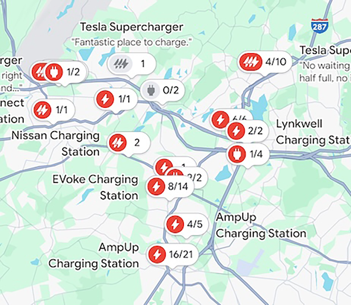
This already exists for most EV charging companies, of course. Brands like EVgo, ChargePoint, and Electrify America all have apps that’ll tell you which banks are open and which are occupied. More importantly, the information for these chargers is also available on Google Maps, meaning you can compare a bunch of different stations and their availability without having to make five new accounts or switch between five different apps.
Tesla’s Supercharger network, the largest network of EV chargers in the country, has had this availability feature for years, too—but only if you were in a Tesla or used the Tesla app. This meant you’d have to bounce between the Tesla app and Google Maps to get a true sense of what’s available. Not the end of the world, but pretty annoying in practice.
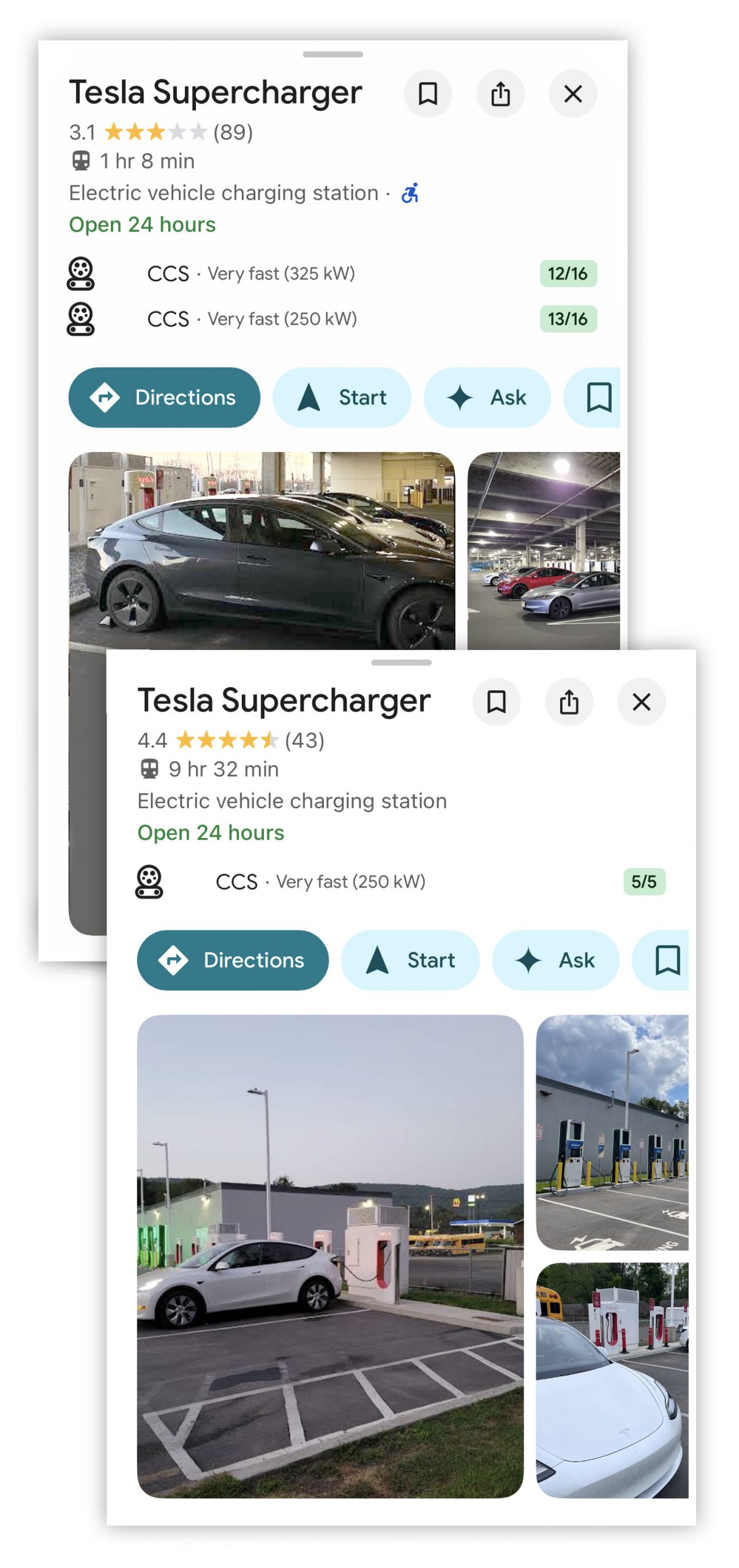
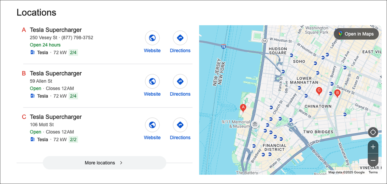
Now, that issue has finally been rectified. As of today, charging bank availability for Tesla Superchargers has finally been integrated into Google Maps. That means you can check Supercharger banks alongside other brands without having to leave the app. Like other charging stations, Google displays how many banks are available out of the total banks at any given location, and info on the charger type (in this case, NACS) and charging speeds.
Why Is This Such A Big Deal?
Five years ago, this feature would’ve been a lot less interesting. But recently, Tesla has unlocked Supercharger availability to nearly two dozen brands, meaning there’s a far bigger population of vehicles that might be looking for a juice-up.
Like I mentioned earlier, this is more about convenience than anything else. Tesla owners have had seamless access to this information for years. Now, people without Teslas don’t have to use the Tesla app to find an empty charging bank—they can do it all in one app that’ll also navigate you to whichever charger you choose.
Stuff like this might not sound like a big deal, but in the grand scheme of getting more people into EVs, it’s a significant step. One of the main barriers to EV adoption is the perceived lack of convenience. Showing people on the fence just how simple it is to find an open charger might make them more likely to buy an EV than another gas-powered car.
Live availability of Superchargers now in Google Maps pic.twitter.com/DJvS83wVxm
— Tesla Charging (@TeslaCharging) November 11, 2025
Theoretically, it’ll also help curb fights over charging stations between EV owners whose cars are low on electrons. I’ve seen my fair share of screaming matches to know this happens more often than you think.
Top graphic image: Google Maps; Hyundai


It would be nice if it actually gave you results based on the charger style you need. I recently had a Wrangle 4xE rental, but I was given it with a completely depleted battery. I wanted to try out the performance when the battery was charged, so I searched for the charger style that the Jeep uses and Google Maps gave me results for every single charging station in the area, regardless of what charger style it was. I had to tap on each icon to find out what kind of charger it was. Since I was also trying to find a place I could eat lunch while charging, it was frankly kind of a hassle (I was staying in a new suburban area, so not all of the map data was updated yet.
Neat, but if I’m going distance I’m taking the Odyssey. Plus all the charger apps already tell you this.
”that’ll tell you which banks are open and which are occupied”
Theres a whole world of difference between “open because nobody is charging there” and “open because it’s broken”
You know what I want more than anything? A heatmap of reported police presence over the past 30 days. We have heatmaps for crime activity, and we’ve crowd sourced reporting police sitting on the sides of the road doing speed traps, but I’d like to know not where they are right now, but where they tend to hang out. You know. For safety.
Slightly off topic but at some point, I’d love to see Google Maps, Waze, etc team up with weatherbug, weather underground, etc to allow for a weather layer on maps. Would be incredibly handy when planning motorcycle routes or just planning for winter weather here in the midwest; it can’t be that hard can it?? Maybe something like this already exists and I just have my head in the sand, the sand of a cold wintery beach in Iowa with a frozen beer.
Replying days later, but if you’re not familiar with this website it offers pretty much exactly what you’re wishing for! https://morecast.com/en/plan-your-route
This is an improvement.
But I’m also just waiting for Google to start pushing charging locations as ads just like all the other paid-ad icons cluttering their map app now.
There’s a 12-bay Tesla Supercharger in a strip mall a few blocks from the airport. It is constantly overflowing, because it is the charger that rideshare drivers who are “working” the airport are keeping it in constant use. There’s no clear queue, so Tesla and other EV are just strewn about, waiting for a bay to open up.
The system needs some work.
Sounds like something that “self-driving” could fix: you plug in, go to work. OR, you get in line.
Car self-moves in line until it is at the charging station. Someone hooks it up. When the car is charged to your pre-set amount, the car simply drives to a nearby open parking space.
Or, we could go old-school and have an actual pump jockey move the car, like a valet service.
Apparently Google Maps has a Low Visibility tag you can apply similar to marking accidents and road debris. I discovered this on a foggy highway where some psychopath took the time to apply that tag every mile so I kept getting prompted to confirm.
You could just ignore the prompts….this is physically impossible for my wife to do! haha
Now we just need Waze reporting to confirm via actual people there, that it is as the Charger vendors says it is.
Idk 9 times out of ten “waze reported” police are no longer there. I think it could work to report broken chargers but real-time changes like charger occupancy don’t seem to keep up.
While they’re adding useful features, could they maybe toss in the ability to turn off the “police reported ahead” alert? I’m trying to get through a podcast, not flee a bank robbery
I’ve had my EV for only 1 month and have only used a public charger once but having this built into the onboard navigation is beyond useful. Knowing what my charge will be when I get to wherever is also reassuring.
Another great utility is https://www.plugshare.com/ since it will tell you more details about the chargers like what the parking lot they’re located in is actually like and such.
Man, that would have been really helpful literally 3 frickin’ weeks ago, when I rented an EV out of AUS (2/3rds the cost of a similar-sized gas car).
EVGo app kept directing me to charger locations that didn’t seem to exist. When I finally found one near one of my destinations, it was in a paid parking garage (not that the app warned me about it). $45 for 3 hours of parking (not that the price was posted anywhere), and I don’t think I got even 30% charge.
Honestly, I bet the reason this took so long to implement was trying to negotiate access to these company’s API’s.
I refused a Tesla as a rental in Scamaheim california. I was worried about access to a charger and loathe to put an app on my phone to pay for it.
The place i stayed for the time I was there had a decent number of empty electric charging stations though. so I was probably worried about nothing in the end, but I gotta say that seems like a bad idea to put rental cars into the mix when the learning curve on how they drive can be steep for some people.
There are few public chargers in my but none near me. Good for travel.
I’m still waiting for Google Maps to integrate the feature where it successfully navigates you to your destination via the most sensible route.
Nonsense. The route with 20 traffic lights that are all 5 minutes long is totally the fastest.
Or the route where a two mile section of road is torn up and it’s one lane with portable traffic lights and cameras at either end? I waited at one of those for like ten minutes at 2 AM, wondering why it was red. Almost took off, and then I saw some headlights come around the corner. That… was not faster. Or shorter.
I think the map programs now sacrifice ‘best’ route with ‘easiest from it to calculate really fast’. Wife’s Waze takes some really sketchy short cuts, or my favorite, make a bunch of turns down a cow track when you could have just driven another 1/2 mile and turned left at light?? Was it 4 ft shorter?
It’s like it doesn’t use any real-time traffic info or previous routes or anything and just has some AI or whatever look at a map and make an educated guess.
Also really, really, deeply love how I will manually choose a route that I know to be the fastest route, but it defaults to the much worse route it originally chose while I am currently driving.
Yes! We ran into this on some road trips around the UK. Wife drives and puts in Waze route on her Iphone. I as nav (wife is terrible nav) will then put route into my Google Maps on my Android to compare and then verify with physical map book that we will be avoiding those 1 lane two-ways if possible (We’re American city dwellers).
Half-way there it freaking ‘recalculates’ to some not so good route! Google maps seems to do this less often.
Our first trip to Ireland in the mid-2000s we bought the Ireland maps for our Garmin and followed along with the AA maps. That was a similar adventure for “best” routes and shortcuts… I was just glad the tractor trimming the hedges left us barely enough room, and we paid for full damage waiver on the rental car.
Ireland is loaded with those tiny roads with zero shoulders! All those rock walls and stout hedges waiting to grab your car.
I believe Conner Pass on Dingle was the most nerve wrecking one.
For what it’s worth, they have to default to “easy to calculate”, because finding the “best” route is literally the textbook example of a class of mathematical problems with no known fast solution (the Traveling Salesman Problem).
Our 2005 Ford Nav had a ‘breadcrumb’ feature that was nice so you could go back way you came. Waze sometimes will route you same way, maybe not….
As an Android user I wish I could year Apple Maps instead.
Dude! Please rephrase to make sense. 🙂
I guess I can’t edit now but I meant to say use apple maps lol.
Nice. Dude! What’s on my back?
Sweet!
🙂 Or are you The Dude who someone peed on his rug?
I don’t yet drive an EV, but what portion of the Autopian audience shares Brians’s view that “most parts of America actually have a pretty robust charging network”?
We have owned an EV for a little over a month now and I have been pleasantly surprised by how many public chargers there actually are. I live in a small to midsize city in mid-Michigan and within 5 miles of my house there is at least 20 public charging stations according to the Chevy app.
Edit to add: Saying “most populated parts of America actually have a pretty robust charging network” is probably a more accurate statement.
“Most parts” is definitely doing a lot of heavy lifting there. In my experience, people who live in densely populated parts of this country frequently fail to grasp the magnitude of difference between that and the more sparsely populated parts of the country. A typical New Yorker will be like, “This one time, I drove I-70 through Pennsylvania and Ohio and man, there was like nothing for miles.” News flash, PA and OH both have population densities around 280/sq mi. Care to guess how much lower the density is in a truly sparsely populated state? Half? A quarter? No. Try an order of magnitude. Now cut that number in half again.
There are certainly still some large gaps in charging infrastructure, but I’d say the statement is reasonably accurate. I had my Bolt for 3 years before there was enough infrastructure to take it on an actual trip, and now we can take it almost anywhere we’d want to go without issues. The most remote spots it has been are the Horseshoe Canyon area of Canyonlands NP, outside of Hanksville UT and Hite, UT- these are in an area that would definitely not be included in the “robust charging” category, but were doable. One of those trips I did some volunteer work outside of Hanksville, and a BLM worker there had a Rivian (with home charging), and offered up his charger in case I got marooned.
When I look on plugshare at most areas of the country out of curiosity, I get jealous at the amount of charging stations most have.
The East Coast has an excellent network of chargers. Even in the middle of nowhere (for the East Coast) there is charging available. It might not be the most convenient but it’s there. On the interstates it’s a non-issue.
I’ve been keeping an eye on the charging network in the midwest because it’s the biggest thing keeping me away from EVs, and I have to say I’ve been pleasantly surprised by the expansion. My area (which is admittedly one of the larger cities in the state) has a bunch of charging locations, and they just built a Supercharger station at one of my regular grocery stores. One of the big gas station chains is also adding charging ports at their new stores.
Maybe more telling, a few years ago it was not possible to drive from my house to my brother’s house across a very rural area because there were no chargers close enough to the route. These days you don’t even have to go out of your way, there’s a charging station right on the roads I normally take.
I suspect the charging situation is better (though still definitely not perfect) than a lot of people realize, even in “flyover” country.
I’m close to an interstate in Indiana. If I hop on and head straight west, the next Supercharger is 100 miles, EVgo is 101 miles. Sticking to that same interstate but heading east, the next EVgo is 450 miles, although by detouring off course by 25 miles there’s an EVgo at 88 miles. Tesla Superchargers are better. There are some other scattered options, but off the interstates they are spotty.
Now if it could just reliably tell me which stations have diesel
I’d like to add onto this – an option for when I’m pulling a trailer, like ‘yes it has diesel, but no you can’t fit in there with a gooseneck attached’.
I would like them to report which ones have actual gas optional and not just Ethanol Blend.
I used this feature last night to pick a tesla supercharger on my way home, I knew it was new withing the past few weeks but didn’t realize it had literally gone live yesterday.
if it shows 2/2 is that saying 2/2 are free or 2/2 are in use?
I think the logic behind the number is available/total
From the article…
They should color code the icon along with showing the numbers
I had instances on the highway when I am cruising just fine and I pass another EV (non tesla) and you are approaching DC chargers soon, I just go for it because you know that car is going to stop there too lol
We prefer to call it a juicy hookup.
We’ve been getting so much flux in highway stops and parking lots. I should probably go see the doctor.
It feels like you should be able to reserve these things and tech should be able to optimize these based on knowing where people are going based on their GPS destination. I know there is some big brother aspect, but most people are putting their destination into the car GPS so just share that so the charging companies know who is passing by and who has the range to make it and who needs a charge. Add on some subscription and premium access and print money.
I think reservations would only work if there was a finanical penalty if you don’t show up to charge.
Definitely, because people are reliable in only that they constantly do horrible people things.
Like ICEing out charging spots.
The few times I’ve seen that at a Tesla Supercharger, it gets taken care of fairly quickly. Quickest I’ve seen was at a Buc-ee’s in SC. Two minutes after reporting it, an assistant manager was talking to the guy. In fairness, the parking lot was crowded and this older gentleman probably needed to make a quick walk for it. The guy did find another spot quickly.
Tesla’s native nav software kind of does that. It takes number of drivers and charge levels into account when making routes. I’ve had it automatically change which charger it navigates to based on occupancy and projected arrival state of charge. Of course humans always can muck up the computer’s work.