
Many modern drivers take their navigation systems for granted. You can get directions to just about anywhere in the world at a moment’s notice from the tiny supercomputer in your pocket. Obviously, that wasn’t the case in the 1930s when cell phones were decades from existence, and humans were decades from the first satellite. The limits of technology, however, didn’t stop one firm from inventing a very early form of car navigation. This is the Iter Avto, the 1930s metal box that used paper scrolls and your car’s speedometer to tell you how to navigate.
Humans have been concerned with navigation since as far as we can tell. One of the oldest known surviving map-like objects in history is a mammoth tusk with what is believed to be a sort of map engraved into it. How far does that date back? 25,000 BCE. Even paper maps date back well into BCE.
As Hagerty writes, the first successful road atlas was ‘A Survey of the Roads of the United States of America,’ which was printed onto plates by Christopher Colles of New York in 1789. Rand McNally, a name iconic for maps today, printed its first map in 1872, and that was a railroad map.

Hagerty notes that one of the first truly useful maps for motorists was ‘The Official Automobile Blue Book,’ which was published in 1901 by Charles Howard Gillette. This wasn’t exactly a map as we know them today, but a sort of dead reckoning navigation. The book had you navigate by starting at a point, driving a certain distance, turning at a point, and driving more distance. It was inexact, and if something changed that the book didn’t know about, such as a landmark, you were screwed. You were also lost if you didn’t have an accurate way of tracking mileage.
Still, the guide became immensely popular, so much so that AAA would become its official sponsor. But the Blue Book wasn’t the only game in town. In 1904, Rand McNally got into the business of road maps for car drivers.
One of the next biggest steps forward in navigation was figuring out how to take the sort of turn-by-turn directions introduced by the Blue Book, combining it with an accurate map, and scaling it down to an easy-to-digest size. One of those was the Iter-Auto, and it was an automated navigation system all the way back in 1931.
Automating Maps
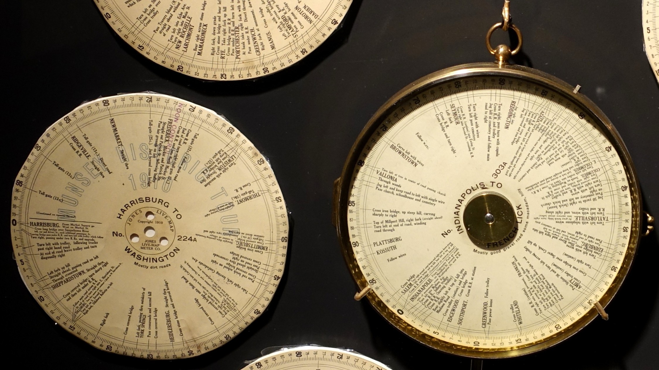
Possibly the first automated turn-by-turn car navigation system was the 1909 Jones Live Map by J. W. Jones. How Jones pulled it off was that he printed directions on paper discs. Those discs were then connected to a car’s odometer. As the odometer turned, so did the disc, and an arrow would highlight your next driving instruction.
This was a big deal in the era. Sure, America’s road network was nothing like how it is today, but America’s automakers were churning out more than 75,000 cars a year by this point, and people wanted to figure out how to get from one city to another.
In 1921, John J. Bovy was granted a patent for a novel car navigation system. Bovy’s invention consisted of a box, inside of which sat a map printed on a scroll. That scroll was wound around two spools, which were tensioned with springs. As you drove, you were supposed to spin the scroll. Ideally, this meant that you had a more immediate idea of where you were, but this depended on your moving the map accurately.

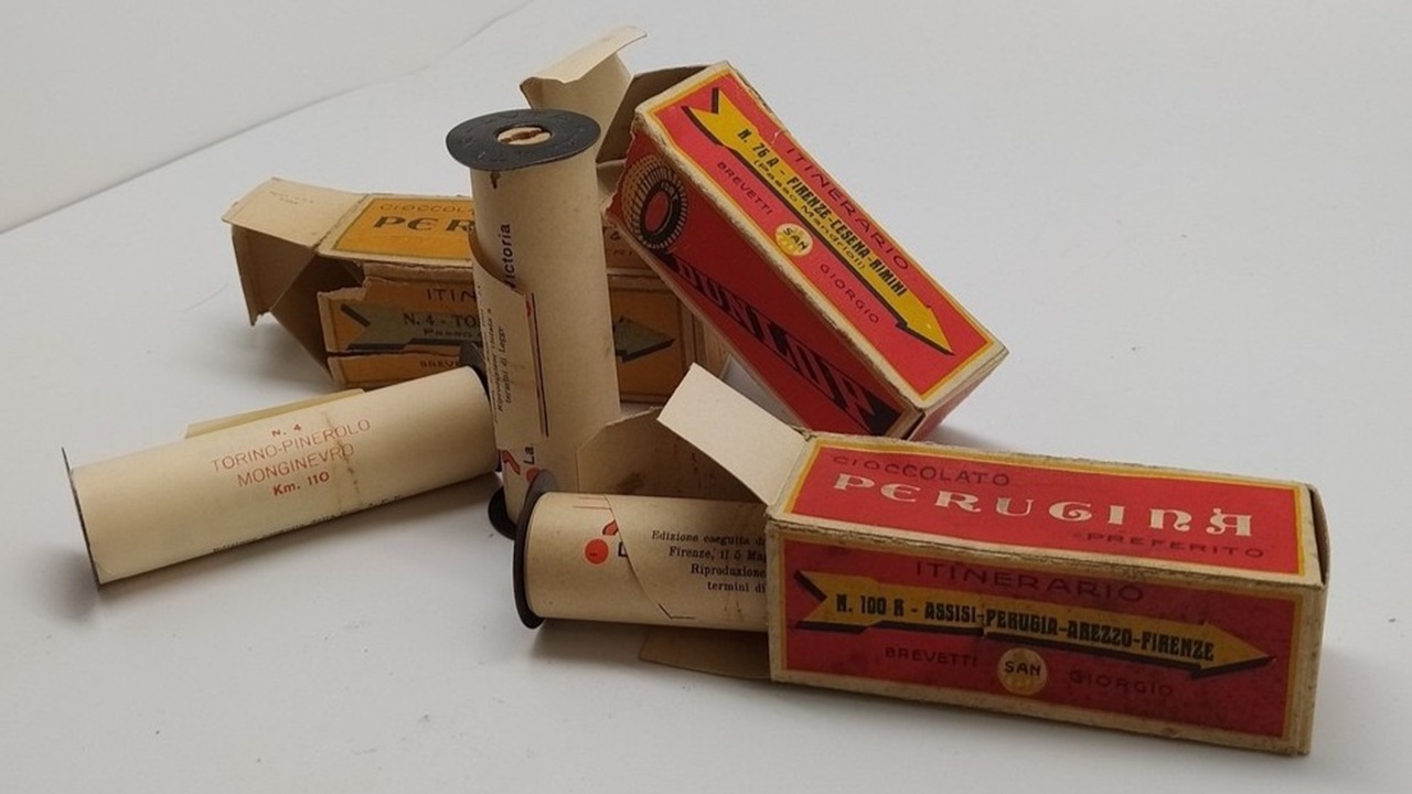
The next big jump came in the form of the “Plus Four” Wristlet Route Indicator & Golf Scorer from England in 2927. This device was similar to Bovy’s invention, but the creators of the “Plus Four” Wristlet Route Indicator & Golf Scorer managed to scale the map scrolls down to about the size of a watch face. These tiny scrolls were loaded into the box, and the person wanting to navigate somewhere would wear the navigator like a watch.
The tiny road maps, which came in a cute box with the watch, had set routes, such as London to Bournemouth and London to Edinburgh.
The Iter-Auto

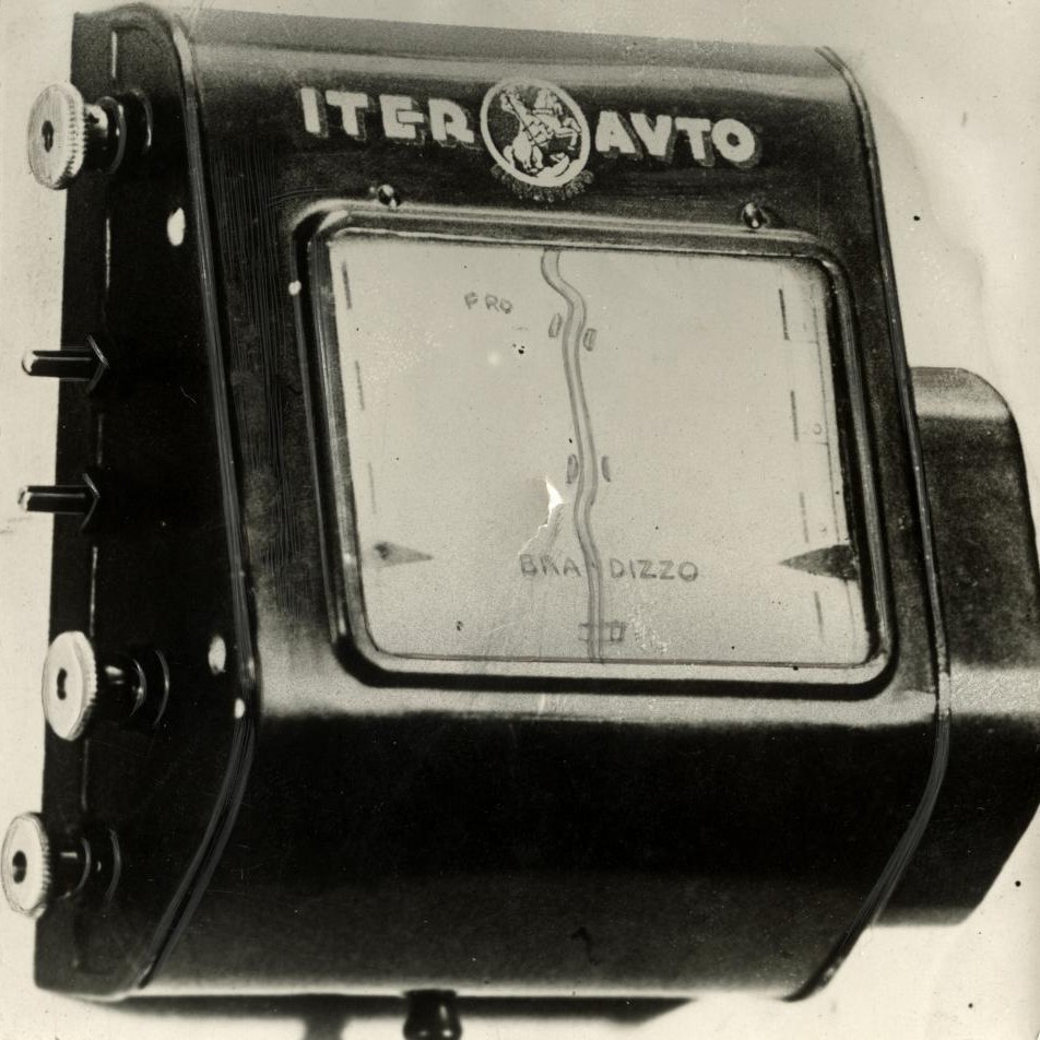
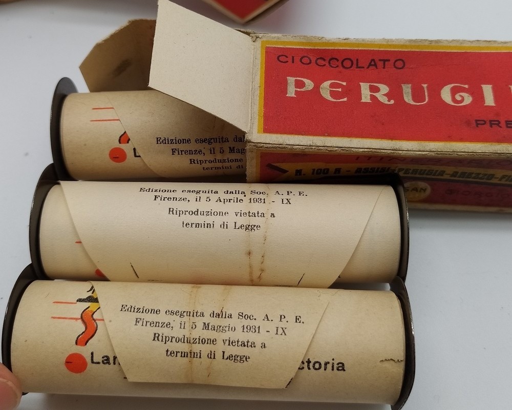
Combine all of these ideas together, and you get Iter-Auto by the Touring Club Italiano of Rome, Italy. Made in 1931, this device utilized a little bit of everything that we talked about thus far. It was a turn-by-turn road map, but scaled down, put into scroll form, and placed in a metal box. The scrolls were made out of paper, and the spools were made of wood and metal. Each scroll was just under four inches wide and was 80 inches long. To improve on the last time this was done, the scrolling mechanism was connected to the car’s odometer.
The Iter-Auto’s scrolls were simplistic. They didn’t have much detail. Instead, drivers largely got a white page with an orange or yellow road in the middle. This road map would move based on the scrolling of your car’s odometer. Features on the map included distance markers, locations of gas stations, points of interest, locations of bridges, locations of railroad crossings, elevation changes, curves, and cross streets.
Of course, none of these navigators got you to specific destinations. They were more for helping you get from one town or city to another. If you had no idea how to get to the starting point, you had to break out your paper map or ask for directions. It was the same deal once you got to the destination city. The navigators only got you to the city. You were on your own after that.
Of course, these systems had other limitations, too. If the scrolls got stuck, they stopped being accurate. If the road changed for any reason, the map would be inaccurate. The scrolls and boxes also couldn’t help you if you took a wrong turn or had to detour around a crash or construction. All of these systems assumed that you’d be able to complete them.
It would take another 60 years before satellite-based navigation would reach the dashboards of production cars. In the decades between the Iter-Auto and the 1990 Eunos Cosmo, there had been developments of increasing complexity. For example, on October 15, 1971, BBC’s Tomorrow’s World reported about a cassette tape-based voice turn-by-turn navigation system.
You just have to watch this, because it’s great:
This system worked a lot like the Iter-Auto in that it matched the movement of the vehicle to navigation, but it had some computerization and had pre-recorded phrases rather than a physical map for you to look at.
General Motors would come out with a complicated system in 1966, called Driver Aid, Information and Routing (D.A.I.R.), which used punch cards, lights on the dashboard, and magnets in the road surface to determine your location. The system was also like a rudimentary OnStar in that it could be used to dispatch help in case you run out of gas, crash, have a flat tire, or just need help. Here’s how General Motors described it:

For the route minder, the driver uses a special card punched for his destination. The card fits a slot in the console. The routing equipment is activated by signals from magnets buried in the road at each major intersection, and compares the signals with the punched instructions on the card. Panel lights will tell the driver whether to turn left, turn right, or go straight through. With all major intersections coded, it would be possible to travel across the U.S. by the system’s direction.
GM also explained the system’s features:
1. Coded emergency messages from car to automatic recorders in a service center, with voice acknowledgment from the center, and voice radio communication from car to service center and servicе сenter to car.
2. A roadside-to-vehicle communication system that transmits audio signs. These voice messages to the driver can include emergency traffic bulletins about the road ahead, as well as information on upcoming accommodations and service facilities.
3. A visual sign minder, triggered by roadway signals from magnets or lowfrequency transmitters which repeats highway sign information on a panel display inside the car.
4. A route minder that guides the driver to his destination without use of maps. Equipment includes a prograrmmed in-car route selector and route direction indicator activated by coded roadway signals.

Sadly, since this system required magnets to be embedded into highways and spaced three miles to five miles apart, implementing it would have been an incredible undertaking. Apparently, GM pushed for a nationwide effort to embed magnets into every highway in America. The system never went into production.
Honda would also take a swing at this in 1981 with the Electro Gyrocator. This used helium, a gyroscope, a CRT screen, and semi-transparent maps to effectively locate the vehicle. From IIEE Spectrum:

“Honda developed a number of devices to make the Electro Gyrocator work, including a gyroscope that had two wires in a stream of circulating helium. When the vehicle moved straight ahead, helium hit both wires equally, keeping them at the same temperature. When the vehicle turned, the flow of helium deviated to produce a temperature difference between the two wires. An onboard computer could detect that difference and translate it into directional information.”
Honda’s system, which was available only in Japan, added 20 pounds to the weight of the car.
Awesome Old Technology

Let’s go back to 1930s navigation. Sadly, while the Iter-Auto was relatively popular in its day, it’s believed that not many survived into the modern day. So, if you want to experience what it’s like to motor like you’re from the 1930s, you’ll have to use another scroll-based navigator tool.
Honestly, I think the Iter-Auto might be more impressive than GM’s and Honda’s craziness. The Touring Club Italiano seemingly stretched 1930s technology to its limits. Like I said, this happened decades before space programs, the launches of satellites, and even before the advent of computers that took up whole rooms. I just love this idea of tying navigation to an odometer.
This makes me appreciate the innovators that we have today even more. It’s trivial to drive almost anywhere in the world, and the computer in your pocket is amazing. I can only imagine how the people of the 1920s and 1930s felt when they learned their car could somewhat tell them how to drive to the next city.
Top graphic images: Nationaal Archief – Public Domain


_-_DSC06690.JPG)
As a car nerd and a photography nerd, I have to wonder if the scrolls are using reel from a roll film camera of some ancient format. The wood/metal reels looks very similar if not the same as old 120 and 616 film reels
The RAF sometimes used roll-maps in WW2
Imagine telling people in the 1930s that the future of automotive navigation was artificial satellites (like the moon, but tiny) that a tiny calculating device with a radio antenna used to determine your coordinates on the Earth’s surface. And that everything would be connected to electronic clouds that sold your coordinates to everyone and put ads in your car.
I feel like studying for my Private Pilots Lisc in the 90s helped me read maps and get a better sense of direction even in a car. Of course back then little Cessnas didn’t have GPS, that was for the commercial stuff. So it was maps, radio beacons (VOR, ADF, compass). I always like it when a car has a compass and my mind immediately thinks 0, 90, 180, 270 when it moves N, E, S, W… then adding or subtracting 45 for the stuff like NE.
My grandfather was a navigator on a Convair B36 and he would tell me about celestial navigation what was some wild stuff. Using stars, sextant and compass bearings, intermittent radio beacons, and umteen maps for missions from Carswell AFB to Alaska or the reverse route.
So as a kid I had an idea to use ATT long lines towers to broadcast signals and let cars sortof have their own triangulation or at least arrow and distance meter to point you to a certain destination. This was like 1987 in elementary school, I was a weird kid… I wrote a science report on it, because stuff like dinosaurs was lame to me.
I believe they still use paper rolls for navigation with the Antique motorcycle Cannonball and the Hoka Hey Challenge
Dakar too.
Dakar is exactly what I thought of when I saw the headline. Although they have switched over to an electronic roadbook now. I think it’s been that way for the cars for a while, but only in the last few years have I noticed the old scrolling roadbooks gone from the bikes.