
Many modern drivers take their navigation systems for granted. You can get directions to just about anywhere in the world at a moment’s notice from the tiny supercomputer in your pocket. Obviously, that wasn’t the case in the 1930s when cell phones were decades from existence, and humans were decades from the first satellite. The limits of technology, however, didn’t stop one firm from inventing a very early form of car navigation. This is the Iter Avto, the 1930s metal box that used paper scrolls and your car’s speedometer to tell you how to navigate.
Humans have been concerned with navigation since as far as we can tell. One of the oldest known surviving map-like objects in history is a mammoth tusk with what is believed to be a sort of map engraved into it. How far does that date back? 25,000 BCE. Even paper maps date back well into BCE.
As Hagerty writes, the first successful road atlas was ‘A Survey of the Roads of the United States of America,’ which was printed onto plates by Christopher Colles of New York in 1789. Rand McNally, a name iconic for maps today, printed its first map in 1872, and that was a railroad map.

Hagerty notes that one of the first truly useful maps for motorists was ‘The Official Automobile Blue Book,’ which was published in 1901 by Charles Howard Gillette. This wasn’t exactly a map as we know them today, but a sort of dead reckoning navigation. The book had you navigate by starting at a point, driving a certain distance, turning at a point, and driving more distance. It was inexact, and if something changed that the book didn’t know about, such as a landmark, you were screwed. You were also lost if you didn’t have an accurate way of tracking mileage.
Still, the guide became immensely popular, so much so that AAA would become its official sponsor. But the Blue Book wasn’t the only game in town. In 1904, Rand McNally got into the business of road maps for car drivers.
One of the next biggest steps forward in navigation was figuring out how to take the sort of turn-by-turn directions introduced by the Blue Book, combining it with an accurate map, and scaling it down to an easy-to-digest size. One of those was the Iter-Auto, and it was an automated navigation system all the way back in 1931.
Automating Maps
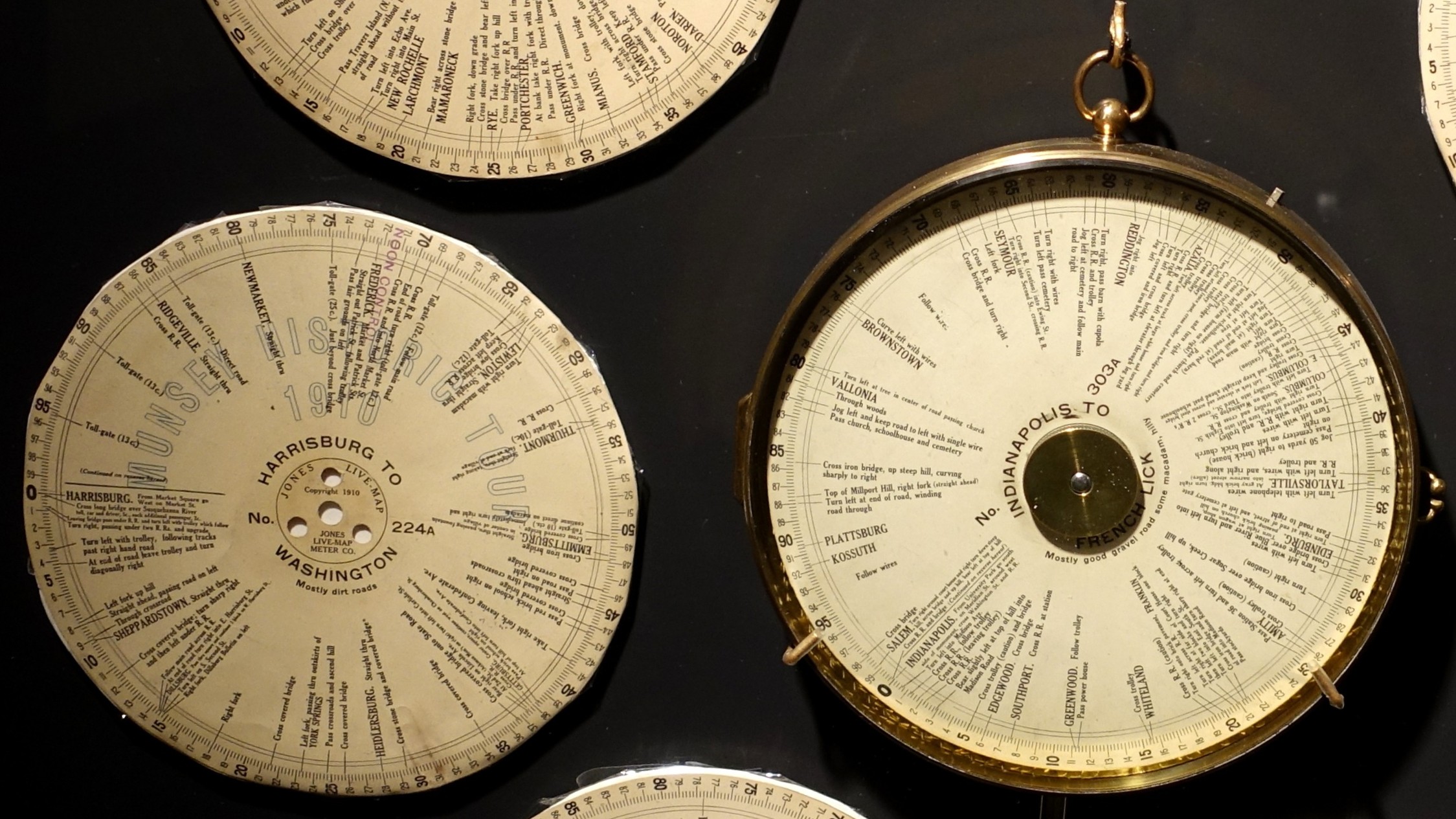
Possibly the first automated turn-by-turn car navigation system was the 1909 Jones Live Map by J. W. Jones. How Jones pulled it off was that he printed directions on paper discs. Those discs were then connected to a car’s odometer. As the odometer turned, so did the disc, and an arrow would highlight your next driving instruction.
This was a big deal in the era. Sure, America’s road network was nothing like how it is today, but America’s automakers were churning out more than 75,000 cars a year by this point, and people wanted to figure out how to get from one city to another.
In 1921, John J. Bovy was granted a patent for a novel car navigation system. Bovy’s invention consisted of a box, inside of which sat a map printed on a scroll. That scroll was wound around two spools, which were tensioned with springs. As you drove, you were supposed to spin the scroll. Ideally, this meant that you had a more immediate idea of where you were, but this depended on your moving the map accurately.

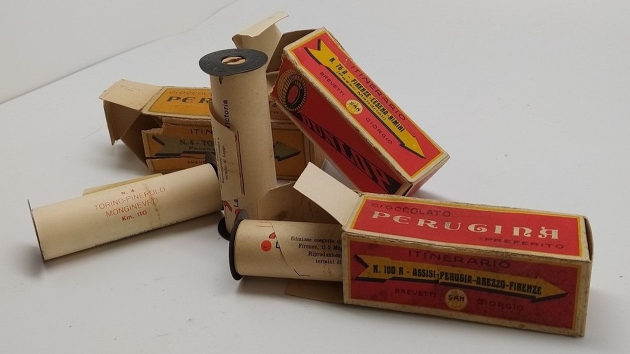
The next big jump came in the form of the “Plus Four” Wristlet Route Indicator & Golf Scorer from England in 2927. This device was similar to Bovy’s invention, but the creators of the “Plus Four” Wristlet Route Indicator & Golf Scorer managed to scale the map scrolls down to about the size of a watch face. These tiny scrolls were loaded into the box, and the person wanting to navigate somewhere would wear the navigator like a watch.
The tiny road maps, which came in a cute box with the watch, had set routes, such as London to Bournemouth and London to Edinburgh.
The Iter-Auto

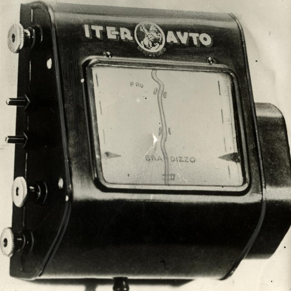
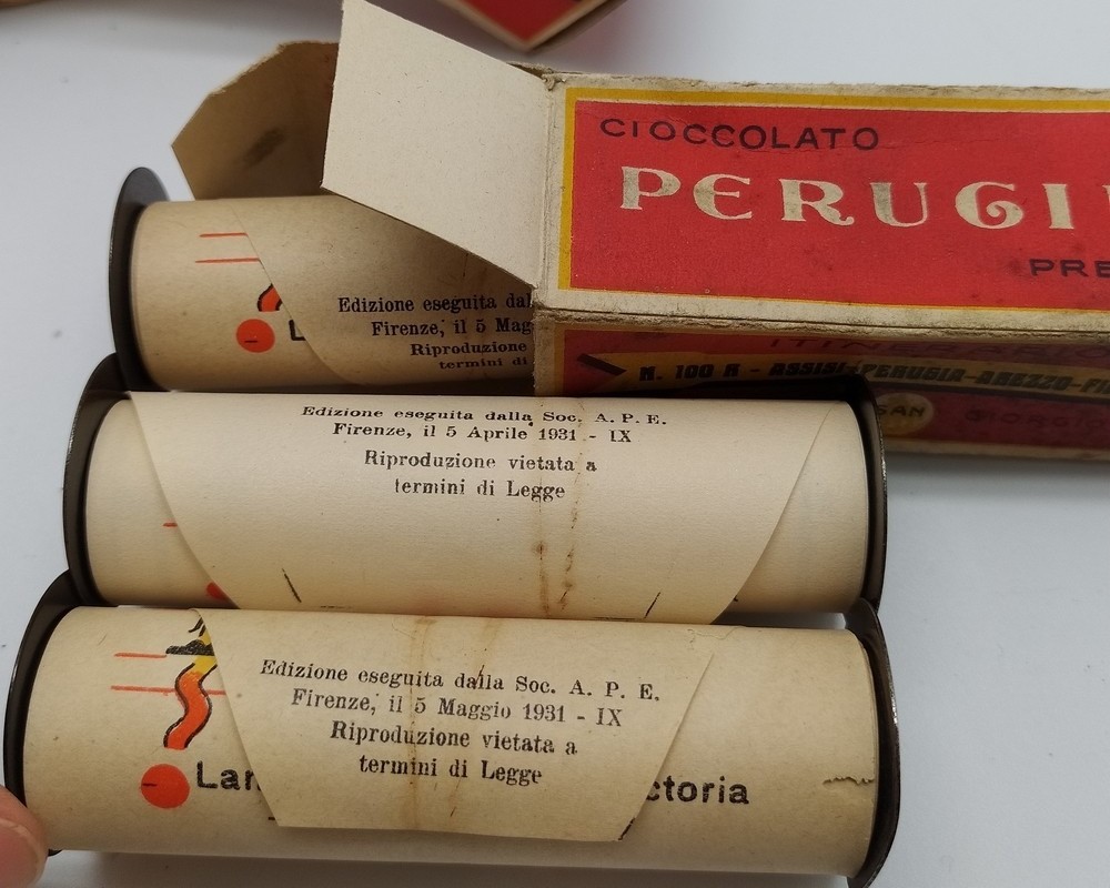
Combine all of these ideas together, and you get Iter-Auto by the Touring Club Italiano of Rome, Italy. Made in 1931, this device utilized a little bit of everything that we talked about thus far. It was a turn-by-turn road map, but scaled down, put into scroll form, and placed in a metal box. The scrolls were made out of paper, and the spools were made of wood and metal. Each scroll was just under four inches wide and was 80 inches long. To improve on the last time this was done, the scrolling mechanism was connected to the car’s odometer.
The Iter-Auto’s scrolls were simplistic. They didn’t have much detail. Instead, drivers largely got a white page with an orange or yellow road in the middle. This road map would move based on the scrolling of your car’s odometer. Features on the map included distance markers, locations of gas stations, points of interest, locations of bridges, locations of railroad crossings, elevation changes, curves, and cross streets.
Of course, none of these navigators got you to specific destinations. They were more for helping you get from one town or city to another. If you had no idea how to get to the starting point, you had to break out your paper map or ask for directions. It was the same deal once you got to the destination city. The navigators only got you to the city. You were on your own after that.
Of course, these systems had other limitations, too. If the scrolls got stuck, they stopped being accurate. If the road changed for any reason, the map would be inaccurate. The scrolls and boxes also couldn’t help you if you took a wrong turn or had to detour around a crash or construction. All of these systems assumed that you’d be able to complete them.
It would take another 60 years before satellite-based navigation would reach the dashboards of production cars. In the decades between the Iter-Auto and the 1990 Eunos Cosmo, there had been developments of increasing complexity. For example, on October 15, 1971, BBC’s Tomorrow’s World reported about a cassette tape-based voice turn-by-turn navigation system.
You just have to watch this, because it’s great:
This system worked a lot like the Iter-Auto in that it matched the movement of the vehicle to navigation, but it had some computerization and had pre-recorded phrases rather than a physical map for you to look at.
General Motors would come out with a complicated system in 1966, called Driver Aid, Information and Routing (D.A.I.R.), which used punch cards, lights on the dashboard, and magnets in the road surface to determine your location. The system was also like a rudimentary OnStar in that it could be used to dispatch help in case you run out of gas, crash, have a flat tire, or just need help. Here’s how General Motors described it:

For the route minder, the driver uses a special card punched for his destination. The card fits a slot in the console. The routing equipment is activated by signals from magnets buried in the road at each major intersection, and compares the signals with the punched instructions on the card. Panel lights will tell the driver whether to turn left, turn right, or go straight through. With all major intersections coded, it would be possible to travel across the U.S. by the system’s direction.
GM also explained the system’s features:
1. Coded emergency messages from car to automatic recorders in a service center, with voice acknowledgment from the center, and voice radio communication from car to service center and servicе сenter to car.
2. A roadside-to-vehicle communication system that transmits audio signs. These voice messages to the driver can include emergency traffic bulletins about the road ahead, as well as information on upcoming accommodations and service facilities.
3. A visual sign minder, triggered by roadway signals from magnets or lowfrequency transmitters which repeats highway sign information on a panel display inside the car.
4. A route minder that guides the driver to his destination without use of maps. Equipment includes a prograrmmed in-car route selector and route direction indicator activated by coded roadway signals.

Sadly, since this system required magnets to be embedded into highways and spaced three miles to five miles apart, implementing it would have been an incredible undertaking. Apparently, GM pushed for a nationwide effort to embed magnets into every highway in America. The system never went into production.
Honda would also take a swing at this in 1981 with the Electro Gyrocator. This used helium, a gyroscope, a CRT screen, and semi-transparent maps to effectively locate the vehicle. From IIEE Spectrum:

“Honda developed a number of devices to make the Electro Gyrocator work, including a gyroscope that had two wires in a stream of circulating helium. When the vehicle moved straight ahead, helium hit both wires equally, keeping them at the same temperature. When the vehicle turned, the flow of helium deviated to produce a temperature difference between the two wires. An onboard computer could detect that difference and translate it into directional information.”
Honda’s system, which was available only in Japan, added 20 pounds to the weight of the car.
Awesome Old Technology

Let’s go back to 1930s navigation. Sadly, while the Iter-Auto was relatively popular in its day, it’s believed that not many survived into the modern day. So, if you want to experience what it’s like to motor like you’re from the 1930s, you’ll have to use another scroll-based navigator tool.
Honestly, I think the Iter-Auto might be more impressive than GM’s and Honda’s craziness. The Touring Club Italiano seemingly stretched 1930s technology to its limits. Like I said, this happened decades before space programs, the launches of satellites, and even before the advent of computers that took up whole rooms. I just love this idea of tying navigation to an odometer.
This makes me appreciate the innovators that we have today even more. It’s trivial to drive almost anywhere in the world, and the computer in your pocket is amazing. I can only imagine how the people of the 1920s and 1930s felt when they learned their car could somewhat tell them how to drive to the next city.
Top graphic images: Nationaal Archief – Public Domain


_-_DSC06690.JPG)
Clark Quinn looks very tense and nervous, and his eyes scream of sleep deprivation. I fear he murdered his wife for giving him the “special look”, and is now following the DAIR arrows to a remote burial spot…
Thanks for this was a fantastically interesting article!! 🙂
Fell in love with Thomas Guides map books when I lived in Pasadena. They’re even still around! Great index and grid system, made unfamiliar addresses fairly easy to find.
Also love AAA paper maps and TripTiks. I’ll still get the paper maps from AAA as a backup if I’m going on a road trip. I find those map vending machines quite handy, the nearest AAA office still had one when I went there a couple years ago.
Whoops, Thomas Bros. Guides got absorbed into another company, not the same thing anymore.
As a kid we used either AAA or gas station maps when needed. Though I don’t know if those were of any use for the “going camping somewhere random in the Colorado Rockies” summer family trips. Those were probably done with a lot of local knowledge as my dad grew up in Colorado and his dad had worked all over there for the US Forest Service.
As a kid, my parents would always get a AAA TripTik, which I used to love to draw on with a highlighter to track our progress. 99% of the time we were driving from NY to West Palm Beach on I-95, so it didn’t take Magellan to figure out where we were.
TIL if you’re a AAA member you can still order the paper TripTiks. I just did for giggles.
I love GPS, but it’s also a symptom of the dumbing down of society. Don’t pay attention to road signs, mile markers, route #’s – just blindly follow the little arrow.
I know FAR too many people who can’t even navigate their community without this crutch anymore.
30 years ago we had large printed road maps, Key maps, and road atlases. They were not perfect, but they worked well. GPS is very handy but it does deprive drivers of a deeper skill of navigating and leaning an area. GPS isn’t perfect either. I’ve been mislead by it on interchanges that a series closely spaced exit ramps and the little screen did not update fast enough to clearly indicate which lane I needed to be in. In that case if I’d gone with my gut, I’d have taken the right path but instead I ended up gonig 4 miles out of the way.
Most county and state roads are well marked if you know what to look for. Always look to see what road you are supposed to be on NEXT.
Agree, and sometimes just getting a little lost in a city is good to find new stuff, get your bearings in an area.
I just moved to a new city. I’m using gps when I actually need to be at a place, but it’s also fun to study the map for a minute and send it without real-time guidance. Gives me a better knowledge of the city, IMHO.
I still keep paper atlases in all my vehicles. They really don’t take up much space, and if I ever need it, it means things have gone really sideways and I’ll be glad to have it. It also gives the kids something to look at when they want to know where we are.
1- the 10th paragraph has a fat-fingered date: “the next big jump…from england in 2927″…i’m guessing “1927”. jay vette commented on this obliquely…
2- as others have noted, a scrolling route sheet is widespread in enduro and rally raid.
3- speaking of rally-raid, the dakar rally is in progress now and excellent coverage in USA on peacock stream. great competition, scenery and emotion (somebody cries pretty much every day – it is brutal). ya, i know it is saudi sports-washing, but very compelling nonetheless – bikes, cars, trucks, sxs’s, stock etc. great tv
Also, it’s IEEE (as in ‘i-triple-e’, the Institute of Electical and Electronic Engineers), noted the IEEE member…
took me a minute to find that typo: hyper-link tag says “…IIEE Spectrum” in paragraph starting “Honda would also take a swing at this in 1981…
Props for the creativity to come up with these systems. One additional drawback to the odometer-based ones: I’d be an anxious mess the whole trip knowing that if I stopped for gas or food I’d be putting myself “off course.”
I suppose you could syncronize at major landmarks during the trip.
Fun! But it also occurred to me there weren’t really highways the way we think of them. So everything was just on the side of the road.
There were later ones that integrated a compass, so it could detect when you turned and recalibrate itself. Basically “I know the driver was on a road with heading xyz, and then they turned and now have heading zyx, which means they just passed through intersection abc and I can restart the counter from that known point”
wow that is incredibly clever/complicated. Good on them!
“Sadly, since this system required magnets to be embedded into highways “
MAGNETS? Good thing that wasn’t implemented or something like this might have happened:
https://media.tenor.com/By7nrydPLx8AAAAM/magnet.gif
/jk
I was an avid viewer of Tomorrow’s World as a kid – every week you saw something that made the future seem impossibly fantastic, and something else that made the future seem like hell on earth. Most of what you saw never made it into production, but some things became ubiquitous. For a geek in the 80s who wanted to be an inventor when he grew up it was great TV.
Not sure if it was related but I also loved that Beyond 2000 show from Australia. I recall they showed some car gps system in like 1990, I think it was Japanese, because of course that awesomeness was!
This is great! It would be neat to see an Autopian article on navigation over the centuries. For example, the Chinese had a differential-based dead-reckoning cart with a figure that always pointed south regardless of the cart orientation.
Of course, naval navigation has always used celestial navigation (sextants, star charts, etc), and that’s still heavily used across marine, aviation, and especially aerospace as a backup to GPS or when outside of the GPS network (like in space).
The inertial and radio-based navigation systems from the Cold War era would make an interesting article I think.
I’ve always liked the big arrows placed across the US for early aviators.
My grandpa was a a navigator on the Convair B36, the amount of work and math they did for missions was nuts. There was a huge radio and beacon network all across the northern part of the US and Canada, but even it had gaps. So he would use celestial. He had mock bombing runs navigation inspections which were basically tests from hell, be accurate over this target from 36000ft and be within 100ft kinda craziness. Was actually busier at times than the pilots, because they would just trade off duties. Tho a B36 was not the most reliable, needed lots of monitoring.
My parents used gas station maps, Dad would get me copies so I could follow along in the back seat. After I corrected my mother a few times, at about age 7, I graduated to navigator.
Best time I had was when I was 12. I told Dad, in Massachusetts, to “stay on 95 until we get to the tall wooden Indian in Freeport, then turn right.” Dad knew where the tall wooden Indian was, so he thanked me and drove. Mom complained all the way from Newburyport to the tall wooden Indian. She had driven by it hundreds of times, but had never seen it.
For those with a little local knowledge: the freeway through Freeport, Maine is now 295, but back then it was part of 95 and it wasn’t limited access from Yarmouth to Freeport.
Those “scroll the paper yourself” navigators are still used! I’ve only seen them in harescrambles and other dirt bike/ADV rides. They’re called roll/route sheets, as discussed here: https://www.dixiedualsport.com/rollchart.html
Came here to say this too!
Me too! Always wanted to run a traditional enduro, but I have enough trouble just riding the trail, let alone trying to follow a route sheet and time the checkpoints correctly
A tradition going back to John Ogilby’s Britannia (1675), the first road atlas of this type! https://en.wikipedia.org/wiki/Britannia_(atlas)#Ogilby's_Britannia
Only 901 years until we get the Plus Four Wristlet Golf Scorer!
Fascinating that the GM system would have relied on a brand new, expensive and rudimentary magnet system rather than trying to develop radio based navigation like Loran-C. That also would’ve required a tremendous amount of infrastructure but at least it could’ve been more supportable.
Not like it matters, the whole thing was probably just a publicity stunt anyway.
Looks like the current scrolling rally notes that motorcyclists still use today.
And we thought driver distraction was a recent phenomenon.
“automated” it may have been, but it still required the driver pay attention to their environment beyond their surrounding lanes. Recent research on phone-based turn-by-turn directions indicates they are not good for our geographical knowledge/cognitive maps
Yup. Whenever someone asks me “Did you take 127 or cut through on Central?” (or whatever) my honest answer is inevitably “I have no idea.” Not proud to admit that.
As a proud Englishman, I navigate using pubs as landmarks. Wouldn’t have a clue about road names.
In New England, we navigate by Dunks (Dunkin’ Donuts) locations.
And we all have at least one memory of getting hopelessly lost because we turned left at the wrong one. Or failed to proceed correctly through the 5.5-way intersection (Boston only).
5.5 way intersection devoid of any signage besides a vague arrow pointing toward nowhere in particular that says “Cambridge.”
God I miss living there.
In RI, people refer to where Al Macs was…it was gone before I even moved here and it’s still a reference point. That and the Apex Building.
Don’t forget the giant bug on the side of the highway. We moved from Providence when I was 3. 39 years later and that thing still gives me nightmares.
Nibbles!
Never knew he had a name. Is he still there, terrifying children? And funny about the apex building—you brought back memories of 2 yr old me taking guesses why the roof was shaped that way and always expecting to see people standing on it one day.
Nibbles Woodaway is his name…the company used to be called New England Pest Control, but they changed their name to The Big Blue Bug Solutions a few years back…so yes, he’s still there.
Funny thing about the Apex Building…we had a big storm late last year and huge sections of the roof blew off, last time I drove up that way a week or so ago, they had actually removed the remainder of the roof panels, and all you could see was the skeletal framework. It’s been vacant for quite a long time now, so my guess is the entire building is coming down in the near future.
When I first moved to RI in the mid 2000’s, I went to the Apex Building to get my license. My guess is that the DMV was temporarily housed while they built or remodeled the main building in Craaaaanston.
I was curious to see what the Apex building looks like now and just read about the redevelopment. Looks like it’s going to stay that way until the yet-to-be-finalized redevelopment plan kicks off. So….years? That’s a long time to have to look at that sad ruin. Sorry for y’all.
Most people in RI are more worried and upset by the Washington Bridge (195) fiasco. If you want to see RI at it’s finest, look up that saga…
Thank you for referring to them as Dunkin’ Donuts, I loathe the fact that they’re rebranding as “Dunkin”…of course I remember as a kid going to my local DD in Horseheads NY where there was a counter, you got your coffee in a ceramic mug, and you got DONUTS.
I am so here for map content!
Back in 2002 I navigated the western USA using a road atlas the size of a pocket notebook. It’s a good job there weren’t too many places to make wrong turns off US 50.
Well that’s progress for ya – When I was a kid my Dad would navigate the continent using a Rand-McNally Road Atlas the size of a… well… an atlas!
(they were big)
MapQuest was a game changer in the early Internet days. I didn’t have a printer, so I would right down the directions on a piece of paper to take with me.
I still do this. I check out the route first on google maps (and use street view to get a look at intersections where I’m going to have to make a turn). Then I write all the turns and road numbers I need on a postit note, leaving out anything I think I’ll remember.
It ends up being a bunch of jargon only I can understand like:
M4(E), J18 N A46, 5 miles on left
(And that’s how you get to the village of ‘Petty France’ from Bristol).
If I do this, I don’t need directions to get me home, because I was paying attention all the way there, so reversing that is easy.
Pre-GPS my company had distance measuring devices that hooked into the car’s odometer but could be calibrated to be reasonably accurate over a mile or two. Technicians would then locate features along a road by the number of feet along the road as driven from the county line.
I supervised an older technician who would go back and redo the surveys several times, noting that the distance varied a foot or two when he checked them. I tried to explain that it was well within the accuracy of the system. I pointed out that he pulled off the road to write things down, thus adding a foot or two. But the tech kept sneaking out and re-doing the work, often three or four times. I finally had to order him to stop and he transferred out with many choice words for ‘that new engineer’.
I’m convinced this is the system my local delivery companies use to bring me my packages.
I’ve found that if I take the directions and draw my own version of the map on a scrap of paper with landmarks and such the act of copying it down makes me remember it.
The bulk of Gen Xers and Elder Millennials around here probably remember two things:
The kids’ toy with the car on the screen and the little steering wheel so you could try to keep the car on the “road” (which was a scroll of the same 12″ of scenery rolling infinitely on a screen)
The other thing that came to mind was the old AAA travel maps called “TripTiks” where you would tell them where you’re going and they’d provide a series of vertically-oriented maps between two major cities. That way you got the detail you needed, along with POIs, and it was a lot easier to manage than a full road atlas or large folding map.
Both of these things were alive and well into the mid-90s or even later.
I do remember that game.
As a weird kid, I LOVED getting the TripTiks when my grandparents and I would go places over the summer and tracking our trip myself. Can confirm nit long before Covid AAA still had a version that you could get from a vending machine in the lobby.
As for the game, there were multiples of the style but I had a Tomy “Digital Derby” that I loved. It had two independent reels that moved at slightly different speeds to at least add some semblance of randomness
I married into a AAA membership, and had never seen a TripTik before, but I remember those being really cool!
I also recall printing out Mapquest directions and following them to a friend’s house in another state.
Oh, I totally remember getting dragged along to the AAA office so mom could pick up a TripTik. And not being allowed to wait in the car because she didn’t know how long it would take
Also, some early base versions of the Ford/Microsoft Sync system were sort of similar, directions for your full route would be downloaded to the car, if you missed a turn or otherwise deviated, directions were paused until you found your way back onto the original route. Unless you stopped and downloaded a new set of directions from your new starting location. There was no recalculating on the fly and also no screen, just audio
I remember both of these things! My parents used to get TripTiks for all of our road trip vacations. Although ours were supplied by CAA, cause Canada.
I should see if my dad has them tucked away somewhere, they’d make a great dashboard prop for my next 80s/90s Retro car meet.
We never used the TripTiks–we’d stop at a welcome center in any state we hadn’t been through within the last couple years and pick up a map, plus we had the road atlas from whatever year we’d last purchased one.
When you could start getting directions online to print out, that was a gamechanger for me.
But I definitely remember the toy. And I’ve played a very old arcade game version of it, too. Definitely more difficult than it feels like it should be (though that could be at least partially attributed to the degradation of the cabinet–that steering wheel was loose).
I also recall printing turn-by-turn Mapquest directions for trips I was planning.
I did that for years for work until I got my first GPS. Nothing like flying to some random place and having to find your way to some even more random place out in the Midwest by paper map.
And as a dude from New England, the midwestern tendency to give directions by compass direction was baffling to me initially. N, S, E, W, is rather meaningless when you have grown up in a place where the roads resemble a plate of spaghetti dropped on the floor, not a grid.
Here, here. Used to vacation with a small binder of pre-printed Mapquest directions for my known itinerary. Served me well through over 11 states until I finally got on the GPS bandwagon. I probably still have a dozen or so state maps laying around.
Remember they used to give you a small local or regional map when you rented a car?
Hertz still has the little printed local maps at most locations, and quite often in a holder on the shuttle busses. Pretty sure anyway, not that I have grabbed on in a decade or more.
I flew three weeklong trips a month in those days, 9 months a year, with two trips a month the other three. Killed a lot of trees printing those directions until I got my first GPS (total game-changer, that little TomTom One). Though now that I think about it, we used the DeLorme mapping software, which I don’t think was Mapquest. Same idea though.
Out of the country I still print out all of my itinerary and reservations and some basic directions and have them in a binder. I’m very comfortable flying by the seat of my pants anywhere in the US, overseas not-so-much.
I do much the same.
Same. Most of the time my cell carrier switches over to whatever its partner carrier is in the other country, but a few times it just … didn’t! Which was great fun for many reasons beyond just navigation.
Exactly. And I am am a super-duper cheapskate when it comes to paying for things like data on a phone.
I got a TripTik for my first big solo road trip. Maine to DC for a fraternity convention summer after my sophomore year in college. Middle of summer, hot as blazes, no A/C in my ’85 Jetta 2dr. I turned 21 on that trip. Still have the souvenir glass from my very first purchased drink, a Hard Rock Hurricane. Memories!
I had the other driving toy as a kid, the one with a 3D circular map where you drove the car around, and the car was magnetically attached to a wand under the map. So you could swap out the cars.
Amusingly, though I am only 56 years old, my AAA card says I have been a member for 60-odd years – I got added to the family plan started by my grandfather when I was in college, LOL. Mom maintains that and I get it for Christmas every year.
Yes!!! Scrolled down looking for this…TripTik were part of my childhood (late 80’s to early 90’s)…on roadtrips, the privilege of sitting shotgun came with the responsibility of navigating using the Triptik. But it was really easy and kinda fun.
As a kid of older parents, I remember using gas station maps that were upwards of 20 years out of date, those years being between when they were putting the Interstate as initially planned on the map and when what was actually built was long since done.
You can still order TripTiks from AAA! Though their processing has become more automated, so sometimes the maps aren’t as centered or oriented to your route as you would like. Still fun to use.
My nephew literally just got one of those for Christmas this year. They’re still around!