
GPS navigation is one of the single greatest advancements in driving technology in the past 30 years. Before GPS, people had to print out turn-by-turn directions from their computer from MapQuest and reference them constantly throughout their drives. Before that, it was good old-fashioned paper maps and road signs.
But thanks to the power of satellite-based global positioning systems, getting to a faraway place you’ve never been before is as easy as pressing a few buttons on your phone. Punch in the name of a location or an address, and you’re fed all the directions in a matter of seconds, even if that place is thousands of miles away.
But even decades into the era of sat nav, it’s not perfect. From time to time, I’ve had my GPS take me down a wrong turn or to a closed road, or a path that didn’t exist at all. It’s pretty rare that it happens, but it still does happen.
There’s one distinct instance of a GPS route screwing me over that I’ll never forget. It was either 2018 or 2019, and I, along with a couple of friends, was driving from New York City to Burlington, Vermont, to check out a Subaru Impreza 2.5RS listed for sale on Craigslist. Today, this car would probably be worth $10,000-$15,000—it was a two-door black coupe with a big wing and a manual transmission, and only surface rust underneath. But back then, it was worth no more than two grand (I think my friend paid $1,800 for it, and at the time, I thought he was overpaying).
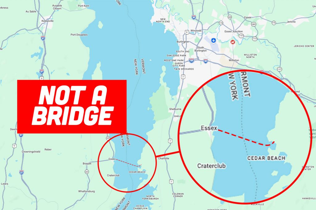
On the way up to Vermont, we stayed on the New York side of Lake Champlain, driving up Interstate 87. As we approached Burlington, my GPS instructed me to head to the town of Essex and hop on the ferry to cross over the lake to get to Charlotte, Vermont, just south of Burlington. Seeing as how it was pretty late in the day by then, and the last Essex-to-Charlotte ferry had departed hours ago, this presented a problem. We had no immediate way to get across, so we had to double back about 40 minutes to cross the nearest bridge. Making things worse was that I was nearly out of gas, and there weren’t very many stations open up there at the time. It was a stressful situation.
Was it partially my fault for not examining the route before blindly following the directions? Yes, certainly. Had I known my GPS was instructing me to go to a ferry that wouldn’t be operating by the time I’d arrive there, I would’ve taken a different route. But also, I feel like there should be some kind of alert built in if the GPS is telling you to take a ferry crossing that isn’t operating 24/7. I don’t remember which app I was using, and this was nearly 10 years ago at this point. Those types of notifications may exist now, and I just haven’t come across one yet.
Either way, it wasn’t a fun time. Now it’s your turn to share. Has your GPS ever screwed you over? If so, how? What happened? Did you end up in a lake like Michael Scott? Please share your stories in the comments below.
Top graphic image: screengrab, NBC


Back in the late aughts, our oldest was playing for a travel youth soccer team. On this day, the game was held on a stretch of lot adjacent to a small airport in Northeast Philly. Our Garmin figured out the best way from Eastern Berks County, and it had us doing the final stretch on the PA turnpike. All good, we got there just fine. The problem was coming home. Much like Michael, I trusted the machine to get me home, and didn’t question when it appeared to be sending us out via a different path. My wife did, but I cast that aside thinking that this technology knew better than both of us.
It didn’t.
Instead of sending us back the way we came, it decided that the best route home was to travel south on Roosovelt Blvd towards the city. From there, it was on to the Rt. 1 expressway and a merge onto the infamous Schuylkill Expressway. If you don’t want to get anywhere fast, this is the route to take. For the record, those were the days before real time traffic analysis – basically it wasn’t taking me that way to avoid traffic or anything, it just decided that me, my kids, and my highly pissed off wife really needed to get home by driving straight into traffic hell.
good times.
I don’t “follow” GPS per se. I look at it before I leave, commit where I need to turn to memory and refer to it later if I need to, which I won’t hesitate to do, but usually don’t have to. The less phone fiddling in my life the better, especially while I’m driving. I have yet to have any problems. I also don’t use the directions made by the GPS, either. I look at the destination and plot my own course. It seems a lot less convenient but it takes no time at all and I don’t wind up stuck on a logging road in the middle of nowhere, which seems far more inconvenient than spending a few minutes looking at a map.
My mom was going to her first high school reunion after my dad passed. My dad was always the life of the party and sort of a social crutch in many ways for my mom. My mom has never had great self-esteem so she was very nervous to attend this event by herself.
My brother and I decided we would drop her off and stay around locally in case she wasn’t having fun and wanted to leave early.
We were in very rural SC (Sumter County) and driving my mom’s elderly ES330 for the ride. After the drop off, my brother and I took to GPS to find somewhere to eat dinner that was decent. This is where things went awry with Waze. We came in on Hwy. 378 and were trying to get to another state highway when Waze decided to make us its science project.
The path it put us on to get from one highway to the next can only be described as a old wagon road with ruts and bumps to which the ES330 was ill-equipped to handle. After some truly uncomfortable scrapes and drags on the bottom of the vehicle, we somehow made it to the next highway rattled but unscathed. Let me add that it had rained the day before and the dirt road was also slippery as well. The formerly clean car was now caked with huge amounts of mud.
My mom had a great time, but when we picked her up, my mom asked, “Why is my car so dirty?” My brother and I laughed until we teared up and told her the story. We have not volunteered for reunion drop offs anymore.
This reminds me of the comparison between GPS Apps:
Apple: Please enjoy this artistic, visually pleasing map while we plan a relaxing route to your destination.
Google: Please observe this straightforward, easy to read map while we plan an efficient route to your destination.
Waze: Put your beer away and cut through this guy’s backyard, there’s a cop up ahead.
It’s more a story of GPS screwing everyone else over who tried to visit us.
We live on a defunct farm at the end of a 1/4 mile dead end road. It’s an old place and used to be the only house on the road so the address was just the road name, no number when my relatives owned it. Eventually a house was built on the corner and we somehow became #1 and they became #3, which is backwards since they are at the beginning of the street. We’re also on opposite sides of the street so one of us should be odd and the other even.
Not a big deal until GPS became popular. My wife started a photography business and clients would come visit. GPS would send them to the house on the corner instead of us. It wouldn’t be such a bad thing but the neighbor is a recluse. His house is falling apart and he get his lawn mowed once a year with a skid steer. He’s cranky and kinda scary looking but totally harmless. That said he doesn’t like strangers knocking on his door.
My wife would tell clients NOT to follow GPS and to drive to the end of the road past the “Dead End” sign but people will follow GPS no matter what you tell them. After a few years GPS finally started getting our address right.
About four years ago they shut the A11 which is the main road between Norwich and the rest of the UK, a few miles from Lotus’ Hethel factory.
I used to cycle to work down an old single track road that had been closed to road traffic for at least 20 years at this point. The railway line crosses it so it had padlocked gates at the crossing that were only ever used by the farmer, and a couple of pedestrian gates you could get a bike through, which had green or red lights on them depending on how close a train was.
For the first few months of the A11 roadworks I’d quite often find a few cars parked at the padlocked crossing gates, staring at a green light, waiting for them to magically open. SatNav had it as a neat shortcut, so people would drive up it, start waiting, then get blocked in by the cars behind them, none of which could turn round because the road is too narrow.
Either SatNav got updated or I’d ended up having a short conversation with all the people dumb enough to blindly follow it about the importance of reading “Dead End” signs, and how it’s best to reverse a few hundred metres and turn round in a driveway, rather than than backing into a field entrance blocked with buried steel pipes.
Just a few years ago, probably 2005, I bought the TomTom XL Europe. A splendid device.
With abundant smartphones, we really have come quite a long way on just a few years time.
My very first GPS experience was kind of funny. I got a rent-a-Taurus that had one of Hertz own very early GPS units, hardwired to the car. Multiple DVD-based, and the graphics were basically that of BattleZone. And it turned out that where I was working that week was on one DVD and my hotel was on another. It was a DVD changer, so that wasn’t a problem per se, but it took a LONG time of the screen going blank and saying “updating” every time I crossed the “border”.
But that was what made me buy my own TomTom One when they came out – the first relatively cheap GPS. Made my life on the road sooooo much easier than printing out directions from Delorme Map ‘n Go.
Another neat one was my ’01 Range Rover HSE – it came with “off road” GPS. You could pin your location and it would remember your track so you could get back where you started from, displaying a breadcrumb trail on the screen. Also DVD-based, but only one DVD for the whole country. High-tech stuff for 2001, and still working fine when I bought that truck in 2014 or so.
Oh, ditto on the Landrover GPS.
About fifteen years ago, after a serious bender, I woke up in the house of a Belgian girl for whoms hand I was competing (My now wife).
Her mother invited us on a cross country trip to a weekend house she had rented. I got in the back seat of her Discovery, only to find out her gps was stuck to “off road” for some reason (weird electrical Landrover glitch).
We were short in time and her mother drove about 300 km high speed rally stile off road. While chainsmoking.
I was beyond nauseous.
To this day, I still cannot use the words Landrover and comfort in the same sentence.
Yikes! That sounds completely horrible! But you found the (hopefully) love of your life, so silver lining!
Not GPS per-se, but a software issue. When I did European Delivery in 2015 for my M235i, if you had navigation BMW did not load the car with European maps. Instead they gave you the Euro maps on a thumbdrive that had to remain stuck in the USB socket in the armrest. And come to find out, while the GPS worked in Hungary, there was no street address database for Hungary – just the roads database. You could either manually move the crosshairs with the iDrive knob and it would guide you to that location, or enter where you wanted to go via latitude and longitude. Fun! Discovered this when we (my mother and I) set out from our hotel in Vienna on the three hour drive. Luckily, I have lived in Budapest for the best part of a year in total, so I knew my way around. And I knew where the Intercontinental Hotel was along the Danube, so I was able to use the crosshairs method. But that would have been all sorts of fun if I hadn’t been there before! Managed to get us where we wanted to for the five days we were there visiting friends and touring around, then worked normally again when we headed off to Italy via Austria again.
Annoyingly, when I dropped the car off to be shipped to the States in Paris I totally forgot about that thumbdrive, and it disappeared along the way. I was a nice all-metal BMW key-shaped one that they sell in the Welt gift shop for a decent amount of cash! Wankers. I have another one they sent me as a thank-you that has all the brochures and what not for the car on it in a nice presentation box though. Lots of goodies in 2015 vs. 2011 when I did it the first time – full tank of gas, custom engraved keyfob, a nice H/K Bluetooth speaker for ordering the stereo upgrade. A set of hazard vests because we were going to France, and some other stuff. In 2011 the car had enough gas in it to get to a gas station and they gave me a 10E gift card for the gift shop, LOL. Which I used to get the same key fob they gave for free in 2015, LOL!
When I did it in 2011 for my 328! wagon, I just bought the European mapset for my TomTom. Worked great! Though I went north on that trip, to Denmark, Sweden and Finland, and dropped the car off in Amsterdam.
The view from my hotel room in Budapest was terrible. 🙂
https://photos.app.goo.gl/e4MEmV8bduecCi6R6
In 2008, I was towing a 20 foot sailboat from San Francisco Bay to Clear Lake in northern California. I blindly followed the directions of my Garmin GPSmap76CSx (which I still have) on a shortcut. When we ran out of pavement, and a sign indicated that a trout farm was 5 miles further, we decided it was time to find a place to turn around. We think we found a small dirt road on the other side of the hill that also led to the trout farm. Turning around was the good choice.
In fairness, this was mostly my fault. But my first time visiting Southern California I had a Mini Cooper S from Turo. Decided I want to enjoy at the back roads so ingoing from Los Angeles to San Diego, I set Google maps to avoid freeways. It flashed a little warning saying that my route may include private property, which I assumed meant that it was going to take me through a gated community or a state park or something. Nope. Camp Pendleton. And my dashcam got it all for posterity: https://www.youtube.com/watch?v=KTpypKO3hek
I had a solo ticket to see Gordon Lightfoot, years ago, back in the “Print Out Mapquest” ages…..and they got me so lost i never saw the show
(Honestly…it was my fault, im 57 and live 1 mile from where i grew up and still get lost in any of the surrounding towns)
“Ah hah…road maps!”
Anyone get the reference?
Spatula City!
I love UHF! Ha ha
“What better way to say I love you than…a spatula!”
“Buy 9 spatulas, get the 10th for just 1 penny!”
“I love spatulas so much…I bought the company”
We were in Broken Bow, OK. We (me, my wife, and three of our kids) decided to go to an escape room.
We reviewed our options on their website, and there was one starting soon that the story was being trapped in a remote cabin with a scientist)serial killer. Looked fun.
So we plugged the address into our trusty GPS and headed out.
The directions seemed to be taking us out of town, but we had pretty much zero familiarity with the area, so we just followed the instructions.
Civilization quickly became sparse, night was falling, and eventually, the GPS told us to turn down a dark, tree lined dirt road that appeared to lead only to a single cabin on top of a hill. The only light came from a flickering porch light on the cabin.
I looked at my wife who was driving and said “Oh HELL no! I have SEEN THIS MOVIE, and we are absolutely NOT going down that road!”
We turned around, called the escape room place, got directions, and had a great time.
Most importantly, we were not killed, raped, and eaten (in that order) by hillbilly cannibals.
One year I drove to Romania from the UK. My GPS decided that the quickest way to get past Budapest was to drive through Budapest, rather than along either of the two perfectly adequate freeways that go around the edge of the city.
And when I say through Budapest I mean right through the centre – across the famous Margit Bridge:
https://en.wikipedia.org/wiki/Margaret_Bridge
I miss not having GPS. Back in ’02 I was in the US and travelled all over the mid-Atlantic region using Mapquest printouts from the local library. And then I drove to California using a road atlas the size of a pocket notebook.
Most annoying is Old US 40 at the top of Donner Pass, California. When Caltrans sets up chain controls on highway 80, you used to be able to duck onto the old highway, drive around the traffic waiting to get through control, and jump back on 80 a few miles down the road (after going through chain control with a much shorter line). Then Waze et. al started routing everyone onto the side streets, and now Caltrans shuts those down, too.
The most fun was a highway closure due to a wildfire on our way to do some camping. Google routed everyone onto a forest service road which started paved, then turned to dirt, then to a narrow 4×4 track, then to a narrow, sandy, 4×4 track through BLM land where people had already set up for their weekend of camping. It really wasn’t that bad of a road, but the semi-trailer that attempted it and tore off a steer wheel was very amusing. At least he pulled it into a sandy area and away from the bumper-to-bumper traffic of very unprepared travelers. That was likely a very expensive recovery.
Not nearly as bad as that one but that one that will always stand out to me happened last year. I was traveling across town for date night with my girlfriend at the time. Anyone trying to cross a large metro area during rush hour know how difficult that can be.
Anyway, the exit I usually take is all backed up but I (mostly) know another way around so I slide over past it and wait for Google to re-route me. It does, telling me to make a u-turn in 2.3 miles. On the interstate. Which is not only very illegal, the exact spot it wanted me to make said u-turn was a concrete wall between the lanes.
I have a screenshot of it around he somewhere. Pretty sure I stared at it and just went “What the [expletive]?!”
I was on my way home from Dulles one time. The route involves taking US 15 for several miles. Google said there was a 10 minute delay, as there often is, and recommended an alternate route. I ended up driving through a rural part of VA, including unmarked dirt roads and eventually popping me back out onto 15. Only now I had to make a left turn across heavy traffic into heavy traffic. Oh, and there was a long line of cars in front of me waiting to do the same. An hour and 20 minute drive turned into more than 2 hours because of google having me avoid a “10 minute delay”. On the upside, VA is a pretty state once you’re out of the city.
I feel old gps is far better than new gps because all the crappy apps are listed first and are poorly designed and try to make money steering you to advertisers despite required driving in the opposite direction.
paper roads like to fuck with GPS LOL
Ruralish VA when I was looking at homes out there in 2023. I was driving my 92 D250 (Which is stock with faded paint and a unpainted black primer fender) Google maps gave me the wrong shared driveway to a home and the drive way I went up the lady freaked the fuck out and started yelling at me and attacked my truck with a rake. So she damaged my truck and I noticed later on part of my taillight is now cracked. I always question why the hell would that be someone’s reaction to someone accidentally driving up their driveway? She is lucky I am not someone trigger happy and know to keep my cool in situations like that.
Just ugh was ridiculous all I needed to do was pull up her driveway and turn around as it was way to curvy of a driveway to try and back all the way up in my hoopty. Which she blocked me from going any further and I was on an incline and my truck being 2wd and manual yeah not the greatest for it so it kicked up some of her “freshly put down stone” driveway (which was put down completely incorrectly and was the wrong stone). So when backing up I accidentally went off said driveway hit some loose dirt and got stuck and had to have a tow truck come pull me out. She also called the cops on me for ?????? so that was fun.
I guess morale of the story watch out for crazy people and don’t drive up wrong driveways?
Oh and I did not look at said home I was supposed to look at my realtor called me and even heard the lady yelling at me.
That’s really scary. I wouldn’t want to live near her either.
Generally the people who freak out are either:
-mentally unwell
-hiding something illegal.
I give 50/50 odds, and neither one is worth fighting with.
slightly related, apple maps is actually great these days, it’s also much less cluttered and easier to read (in my opinion) while navigating compared to google maps
its best feature is “preferred route” which learns your favorite way between two points and suggests that unless it is substantially worse, traffic-wise
on the way home, google maps has me take a later freeway exit that is technically a shorter drive but my way takes me off an earlier exit, takes ~3 minutes longer, and prevents me from having to drive over (and potentially wait at) the godawful railroad tracks near my house
apple maps suggests the exact way i would get home if i weren’t using navigation almost always and it’s wonderful
I’m convinced no one who works on Google Maps has ever driven in Italy.
I had a Fiat 500e with only enough of a charge left to get me home from Hollywood after work. Unfortunately, there was a concert at the Hollywood Bowl and Apple Maps decided to help me avoid that traffic by sending into the very steep hills nearby.
I got stuck behind every other person also on the same nav route, except now we were all trapped on extremely narrow and constantly winding streets. Fun!
Eventually, I generated a few extra miles of range by riding the brakes down from the hills to land right in the middle of, you guessed it, the exact traffic the nav system was telling me to avoid.
This was almost 20 years ago now, in a rural area of eastern Pennsylvania, but my Garmin took me down an unpaved gravel road and across a shallow creek with no bridge that you just had to ford, in order to get to a state park where we were holding a work event. I wasn’t familiar with the area and hadn’t looked at a map, there were much better and more obvious routes all on paved roads that everyone else seemed to take. Fortunately, I was driving a Cadillac Fleetwood at the time, a smaller, lower car could have had a legit issue getting across that stream. It was a legit, public road that did appear on maps, but it was just a really stupid route that hardly anybody would have chosen for themselves