GPS navigation is one of the single greatest advancements in driving technology in the past 30 years. Before GPS, people had to print out turn-by-turn directions from their computer from MapQuest and reference them constantly throughout their drives. Before that, it was good old-fashioned paper maps and road signs.
But thanks to the power of satellite-based global positioning systems, getting to a faraway place you’ve never been before is as easy as pressing a few buttons on your phone. Punch in the name of a location or an address, and you’re fed all the directions in a matter of seconds, even if that place is thousands of miles away.
But even decades into the era of sat nav, it’s not perfect. From time to time, I’ve had my GPS take me down a wrong turn or to a closed road, or a path that didn’t exist at all. It’s pretty rare that it happens, but it still does happen.
There’s one distinct instance of a GPS route screwing me over that I’ll never forget. It was either 2018 or 2019, and I, along with a couple of friends, was driving from New York City to Burlington, Vermont, to check out a Subaru Impreza 2.5RS listed for sale on Craigslist. Today, this car would probably be worth $10,000-$15,000—it was a two-door black coupe with a big wing and a manual transmission, and only surface rust underneath. But back then, it was worth no more than two grand (I think my friend paid $1,800 for it, and at the time, I thought he was overpaying).

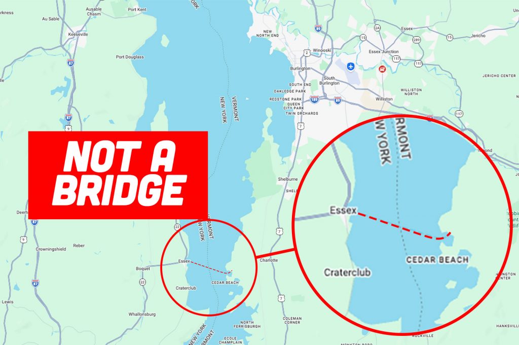
On the way up to Vermont, we stayed on the New York side of Lake Champlain, driving up Interstate 87. As we approached Burlington, my GPS instructed me to head to the town of Essex and hop on the ferry to cross over the lake to get to Charlotte, Vermont, just south of Burlington. Seeing as how it was pretty late in the day by then, and the last Essex-to-Charlotte ferry had departed hours ago, this presented a problem. We had no immediate way to get across, so we had to double back about 40 minutes to cross the nearest bridge. Making things worse was that I was nearly out of gas, and there weren’t very many stations open up there at the time. It was a stressful situation.
Was it partially my fault for not examining the route before blindly following the directions? Yes, certainly. Had I known my GPS was instructing me to go to a ferry that wouldn’t be operating by the time I’d arrive there, I would’ve taken a different route. But also, I feel like there should be some kind of alert built in if the GPS is telling you to take a ferry crossing that isn’t operating 24/7. I don’t remember which app I was using, and this was nearly 10 years ago at this point. Those types of notifications may exist now, and I just haven’t come across one yet.
Either way, it wasn’t a fun time. Now it’s your turn to share. Has your GPS ever screwed you over? If so, how? What happened? Did you end up in a lake like Michael Scott? Please share your stories in the comments below.
Top graphic image: screengrab, NBC


I had a Navigon unit in the mid aughts because I was too cheap to spring for a TomTom or Garmin. It was very, very slow to recalculate routes. Once with my wife and MIL in the car in an unfamiliar area, I was being instructed to do THREE different things because of the staggered calculations with the wife being quickest, the MIL in the middle, and the female voice of the Navigon lagging in last place. After missing a turn because of the cacophony of bossy female voices, I pulled over and told the wife and MIL to knock it off.
This wasn’t a Michael Scott level problem, but when visiting family in an unfamiliar state, we had a family reunion at BBQ restaurant. I usually always use Google Maps, but my brother riding shotgun INSISTED Apple Maps was better. Whatever, I didn’t care, I just put the name into Apple Maps, and it immediately found the correct place: listed the correct address, business info, ratings, etc.
It’s about 30min away, so we head out, but it’s weirdly taking us in the other direction I’d expected. I brush aside my hesitation as I don’t know the area roads and thought maybe it was a ring road or something.
Nope. Apple Maps dumped me in the middle of an auto auction yard in the middle of nowhere. It wasn’t even the correct street name or number block. Totally random location unrelated to the address.
I entered the same address into Google Maps, and it took me back across town to the correct spot, but my brother hasn’t brough up Apple Maps since.
Navigation didn’t do ME dirty, but it affected me pretty bigly one time.
You see, I grew up on a rural road offshoot of another rural road that transverses the Maycamas Mountains in Cali. One stormy evening, a Sierra Nevada Brewing Company bobtail truck got misled- the scuttlebutt was due to a TomTom telling the driver that our little winding lane was a short cut to the next major city, which seems odd since I didn’t realize that commercial drivers like that used such things. Anywho, this poor guy took a wrong turn, and the truck rolled over, spilling cases of beer all over the road.
The whole road got shut down, and I spent the night in the rain in my car waiting for Sierra Nevada to send up smaller trucks to reclaim the salvageable cargo.
Unfortunately, a number of cases of beer rolled into the canyon adjacent to the road and were abandoned by the cleanup crews. Most people with normal thought patterns would look at beat up, muddy cases of Torpedo IPA stuck under copses of poison oak and write it off. Not nineteen-year-old me. I was already getting poison oak on a weekly bases and free beer is free beer. So the next day, I dipped into the canyon, recovered a case of viable beer, and stashed it in our woodshed.
That evening, my Dad came home as was laughing saying “I saw all of these idiots going into the canyon across the road and fishing cases of beer out of the poison oak! How stupid is that?”
To which I said: “What? No way! Who would do such a stupid thing. Unrelated, don’t go into the woodshed.”
Once I rented an Airbnb outside of Traverse City, I put the address on Waze and took off. My friends arrived first but the signal was bad in that area, I asked them for a location just to make sure. I used that location input to Waze and continued driving. I was driving my Volt just to clarify.
The damn gps took me to some dirt road that was only for snowmobiles, full of sand. I realized my mistake after I went downhill to some sketchy part and I had to go to the end to turn around. Well the car was getting stuck and couldn’t go up the hill. I turned off traction control at the bottom of the hill and did a full send it. I barely made it out lol then the adrenaline wore off and my covid shot that I got that morning before the trip fully kicked in. I felt like shit for 24 hours. Never again
We do not own a smart-phone so we rely completely on a Rand McNally atlas, state maps, and a Garmin Drive 5 GPS with lifetime map updates.
The only major time we had a problem with it was when it started to get old and would not hold the newest update on the supplied memory card. So I picked the update that excluded the East Coast since we were primarily using it in the upper midwest.
Fast-forward a couple of months and we had to fly to Florida to visit family so I brought the Garmin along to use in the rental car. Imaging our surprise when it showed we were just driving through fields! There were no roads on the maps!
I did not bring the Garmin cable needed to connect the Garmin to my laptop to update it. The only places open nearby were Wal-Marts and they did not have the correct cable, but could order one.
Since waiting two days was not an option, I ended up just buying a whole new Garmin Drive 52 with lifetime map updates so now we have a spare Drive 5 at home if we need one.
Southwestern PA has a surprising number of dirt paths masquerading as roads and Google Maps has taken me down most of them at one point or another. The one through a cornfield it directed me to in rural Somerset County may have been the best of them – absolutely no way it was classified as a road by any sane motoring organization.
Trying to get to Clear Lake in Oregon, the GPS sent us to the wrong side of the lake, up the forest service roads, instead of up the nice paved highway to the parking area. Let me tell you, a 2WD Toyota pickup is more capable than you think…
Pre-GPS, a set of printed Mapquest directions sent us smack into the center of Oxford, England right at rush hour, when we were trying to get to a pub several miles outside of town. Either Mapquest neglected to tell us about a roundabout, or we counted wrong. I have never seen so many bicycles on the road in my life.
This wasn’t a GPS issue, as I’m about to show my age, but one with a printed off map from a website.
I was on a road trip to LA from my part of the midwest. After a night in Denver, I plotted out route and found a short cut between to highways that would save me some time. So I took it.
It was the Weston pass road. First gravel, then dirt, then single track, then water crossing. I met a few people on ATVs that stared openly at my Audi working its way up the east side of the pass. The road then said 4wd only. Quattro counts right?
Turn out, yes it does. Even in a lowered S4 with summer tires. We made it fine and took no damage. We did not save any time. I didn’t take another short cut on that trip, but I did take the long way around to see death valley the next day.
I had a paid invitation to a political fundraiser which was being held in a private home in the Hollywood Hills. I had never been there before, so I plugged the address into Google Maps….
As I drove along the winding streets in the dark that evening I was a bit disoriented already – then it suddenly told me that my destination was on the left. Which was a blank cliff face – the house was far uphill from where I was.
So I continued along, made a left towards the uphill street – and slowly ventured along to where I saw a bunch of cars parked along the side – but since the streets were poorly marked and the houses themselves had their numbers hidden in the dark I couldn’t be sure which house it was – as Google Maps was offering no assistance at all. Then I saw an Uber with a couple people getting out….
…so I pulled up, leaned out of the convertible and asked “Is this the house where Representative So-And-So is being held?”
And at that moment I recognized Representative So-And-So (who I also had a major crush on) and he said “Yes – but your car looks more fun! We should take off together after this!”
Which, after that event we did – to another fundraiser at The Abbey where he drank me under the table.
Ok, I did have a Garmin in a rental car in the very early days of GPS literally try to send me off the side of a bridge, but I’m not counting that because it’s trite. Instead, I’ll confess I was an idiot…
I was driving from southeastern Virginia to Baltimore. I didn’t bother putting Google Maps on until halfway through the trip when I was in more unfamiliar territory. Google immediately directs me off of the interstate. As I exit, I really don’t understand because it’s not showing any accidents. I try to get back on the interstate and it continues to direct me away. I get on anyway, and it has me jump off at the next exit and my arrival time is terrible.
It took way longer than it should have for me to realize I had Google Maps set to “avoid highways.” I still owned my Triumph Spitfire at the time and that car was just too slow to take on an interstate highway, so I had a habit of setting my GPS to “avoid highways” to find the fastest routes to take it around town. I had forgotten to switch it back. Oops.
25ish years ago I was delivering and installing equipment for customers of the store I worked at as a paid service.
One client lived in a rural area in a neighboring state. Not realizing this, I mapquested the directions, printed a copy, and headed out – only to have Mapquest drop me off at a quarry just over the state line 20 miles from the destination.
To this day I have no recollection of how I actually found the place, but I eventually did.
I don’t know about GPS, but one time Mapquest insisted that I cut across a church parking lot, telling me that it was a street.
Not only was it not a street, it didn’t connect on the other end.
It seems like every time I punch in an address and just follow the directions without checking the route as a whole, Google Maps does something retarded, like making me turn left across 4 lanes of high speed traffic to save 100 yards over a safer route.
I catch a bus at a bus station every morning that’s at the intersection of two main roads. For some reason Google Maps routes drivers through the parking lot instead of turning at the intersection.
Yeah, this is DEFINITELY a thing. Google Maps would inevitably try to have me take a left out of my Dad’s neighborhood across several very busy lanes of traffic when a right, then a U-turn at the next light would have been a LOT safer.
It even decided that was a good idea when I was walking – just go straight across 4 lanes of busy traffic with no crosswalk and then head West to the intersection that you SHOULD have taken me to in the first place because it has an actual pedestrian crossing.
Conversely, trying to get out of MY neighborhood, Google refuses to take the street that goes directly from my house to the major road we need to turn on, and instead routes me through several unneeded turns and a traffic circle to come out onto the major road one block farther West – there’s not a light or anything better about that route that I can see – just 3 extra turns.
And, to add one more generation: when Maps first came out, I had it generate directions to my grandparents’ place in Michigan and I noticed it was routing me across a bridge that hadn’t existed in my lifetime. I actually sent that one in to Google and saw it corrected in about 2 days, so that was nice.
Broadly speaking, Google Maps has trouble with gated communities, of which there are a lot in Las Vegas. There are 3 types of gates: public, with a code or a guard, residents only, and emergency use only. I can’t tell you how many times Google has sent me to an unusable gate.
Only had one bad GPS experience. I was driving to a golf resort in the mountains east of Albuquerque. I wasn’t familiar with the area so I was blindly following GPS on a winding, heavily rutted, unimproved dirt road for about 30 minutes. As it turns it, GPS was bringing me to an old maintenance shack on the back end of the resort property instead of the main gate.
In hindsight, it should have occurred to me that a trail requiring a high ground clearance 4×4 was probably not the entrance to a high-end golf resort. Predictably, the actual entrance involved driving 1/2 mile off the main road on a pristine, newly paved road. So like most GPS fails, the real story here is that I am a bit of a moron.
I made my tee time, though. Played well that day. I had two birdies, which is rare for a 17 handicapper.
At least you didn’t drive into a water hazard. All the stories of people driving into rivers and lake because GPS told them to baffles belief.
I love Bojangles Cajun Filet Biscuit, but until recently there were no Bojangles locally (ironically now that they are local, they don’t seem to offer this particular item, WTF Bo!). I always make sure to visit when I make it home to North Carolina; one day I shall return my beloved pine state!
I’ll also see if I can encounter one on any other random road trip. Many years ago GPS told us there was one about 20 minutes off the interstate so we decided sure. Turns out if was a 40 minute total round trip detour to arrive at an abandoned carpet outlet. #disappointment
Last year in Germany somewhere between Hannover and Hildesheim on the intersection between the A2 and the A7.
It was late at night and when I landed in Hannover I only wanted to arrive to the hotel. I hoped into the rental Ford Focus and just didn’t bother connecting the phone so used the native sat-nav from the car.
However the car failed to recognise the exit to the A7 was closed due to the roadworks so when I went past hoping for recalculation it just instructed me to turn round and go down the same closed exit.
I decided to stop on the hard shoulder in a little spot and connect the phone (lorries blowing past at 90km/h wasn’t pleasant…). And after some wrestling, some small towns and country roads I found the A7 and arrived safely to hotel at about midnight.
The following time it happened about 2-3 weeks after I was unfazed, took the next exit and the sat-nav promptly recalculated itself.
The worst one for me was when I was driving our family’s Mazda5 to a campfire, with my dad in the car. The GPS took us down this “dirt road,” which proceeded to get worse and worse, with bigger and bigger puddles. Eventually we came to a really big puddle. I was hesitant, but Dad told me to go for it. Sure enough, we ended up stuck in this mud puddle, and before long, the engine wouldn’t even start anymore. We had to call some friends to yank us out with an F-150, after which the Mazda luckily did start. According to them, it wasn’t even a dirt road–just a tractor path through the bush!