
For decades, drivers across America have used car ferries to traverse water crossings big and small. But as infrastructure needs have grown over time, many of those ferries have been partially or fully replaced by permanent bridges, which offer swifter, simpler, and more streamlined over-water transport.
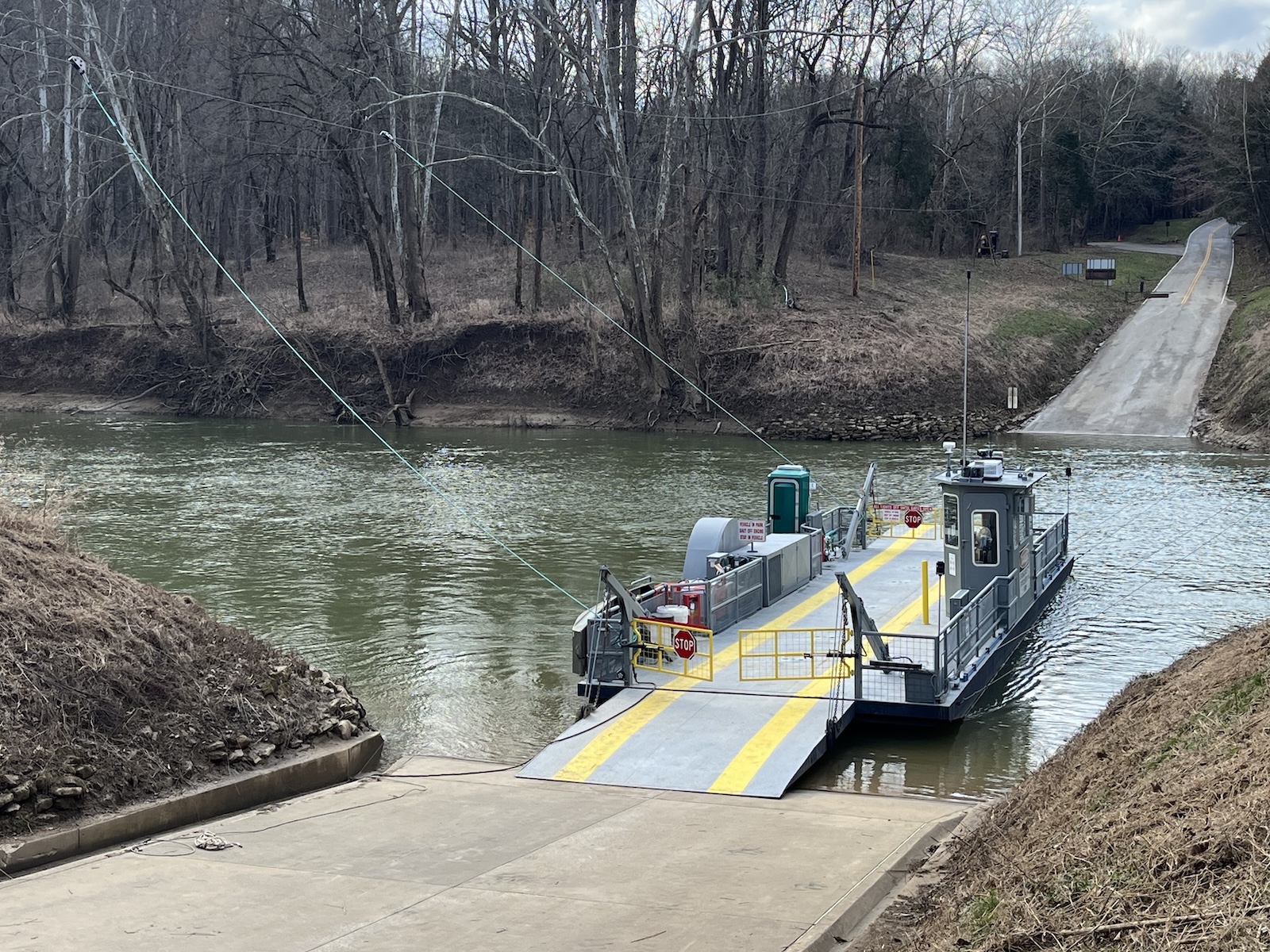
There is one ferry, though, that has stood the test of time. For the past 90-plus years, the Green River Ferry has shuttled cars, as well as bikes, hikers, and other travelers, across the Green River in Mammoth Cave National Park in Kentucky. This is despite the crossing itself being around just 200 feet, and the ferry ride itself taking as little as 30 seconds.
From what I can tell, this is the shortest car ferry crossing in all of America. The boat, a single-engine barge, transports about 135,000 vehicles and 270,000 passengers a year. Drivers have to come up to the crossing, drive onto the boat, and take a 30-second ride across the water. Even with the sheer volume of riders, Mammoth Cave National Park has no plans to replace the Green River Ferry with a bridge, and that probably won’t change for a long time.
Shuttling For Nearly 100 Years
The Green River Ferry was first established in 1934, at a time when car ferries were far more common in the rural United States. It operated for years before the National Park in which it resides was actually established in 1941. Since its inception, it’s been moving travelers, locals, hikers, cyclists, motorcyclists, and park-goers between the banks of the Green River.
The ferry operates continuously, serving travelers 364 days a year (every day except Christmas), from 6 a.m. to 10 p.m. It costs the park about $2 to ferry a car across the river, but the ferry itself is totally free for all who ride it.
The ride itself is a novel experience. All you do is drive down the ramp on Maple Springs Ranger Station Road and wait for the ferry to open its boarding gate. From there, you drive on, put your car in park (or in gear and with the handbrake engaged), turn it off, and enjoy the ride. Once it reaches the other side, the gates open, and you drive off. Simple as that.
The ferry can accommodate up to two vehicles at a time, and can take between 30 seconds and a few minutes to get you across. This video from a recent crossing is a great depiction of how it all works:
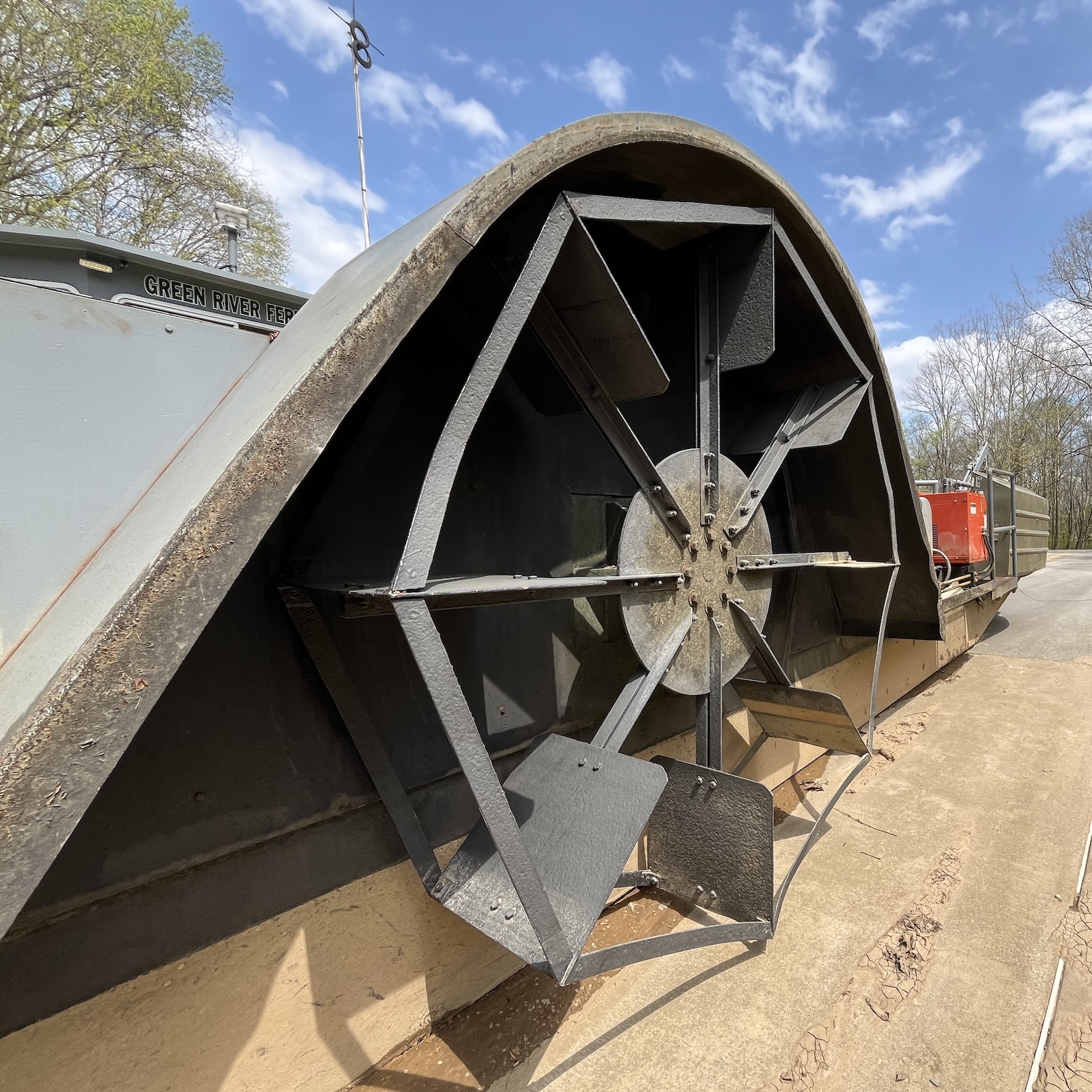
Everything about this ferry just seems like it’d be a fun time (to me, at least). You don’t have to get out of your car, and you can hear the 60-horsepower diesel engine spinning the centrally located paddlewheel. The video also briefly shows what looks to be a normal grate-style park bench mounted on the deck, parallel to the cars, so passengers without cars have a place to sit during the extremely short ride.

I wasn’t able to find any photos of the inside of the pilothouse, located opposite the engine and paddlewheel, though it looks incredibly small, like it could only fit just one person. The ferry requires just one individual to operate; the park says it works on 14 shifts per week (two a day).
Here’s another video showing just how briskly the ferry moves, just to give you an idea of how quickly the ride ends:
If you look closely, you can see that two cables are running from one side of the river to the other, on either side of the ferry, suspended by support towers further up the bank. Those cables each hold additional cables, which are attached to the ferry itself. According to the park, these navigational cables act as guides for the ferry, so it doesn’t get pushed down the river by the current or wind forces. They’re replaced every three to five years.
Here’s a photo from the National Park Service, which gives a better look at where the cables are attached:
The ferry can accommodate more than just normal passenger cars and trucks. As long as your commercial truck or RV is shorter than 16 feet and under 12 tons, it can ride the ferry, too. Vehicles with trailers are another story; the ferry has its own hotline, which you can call to see if your trailer is allowed to ride.
It Might Not Be Fast, But It Is Cheap
In 2015, the National Park Service published a study on the Green River Ferry to assess its service life and propose upgrades to keep it running for the foreseeable future. Back then, the ferry could only accommodate eight tons and suffered from rusting on the hull and the internal stiffeners. Thanks to rule changes by the Coast Guard in 2010, the ferry was now also subject to inspection every two years and a dry docking for comprehensive inspection by the Coast Guard every five years.
The NPS presented several different proposals for the future of the ferry, including performing basic repairs necessary to keep it running, repairing it and upgrading it to carry heavier loads, or replacing it altogether, with a newer, more capable boat. The NPS also briefly considered a bridge, but that idea was quickly dismissed over cost—not just to build the bridge, but also to keep it operational. From the study:
Low and high level bridges were among the alternatives considered but dismissed. A low level bridge would not meet Federal Highway Administration (FHWA) standards related to high water events. While a high level bridge would meet such standards, it would have extensive environmental impacts. The bridge and connected roads would have a large footprint (both length and height of bridge out of context with the surrounding area), require excavation that could impact the cave and karst systems, have a major visual impact, and require removal of vegetation that could impact the habitat of federally threatened or endangered species. The bridge would also cost approximately $50 million to build with additional annual maintenance costs potentially exceeding those to operate the ferry. The study concluded that a bridge would be “inconsistent with the purpose of the project.”
Obviously, the NPS decided to keep the ferry around. The project cost for fixing up the boat would have cost around $3.7 million, according to the study, while building a new boat would’ve cost $4.6 million. Instead, they went for the middle option—restoring and upgrading the boat to handle more capacity—for $3.9 million. Not cheap, but a far cry from that $50 million needed to build a bridge.
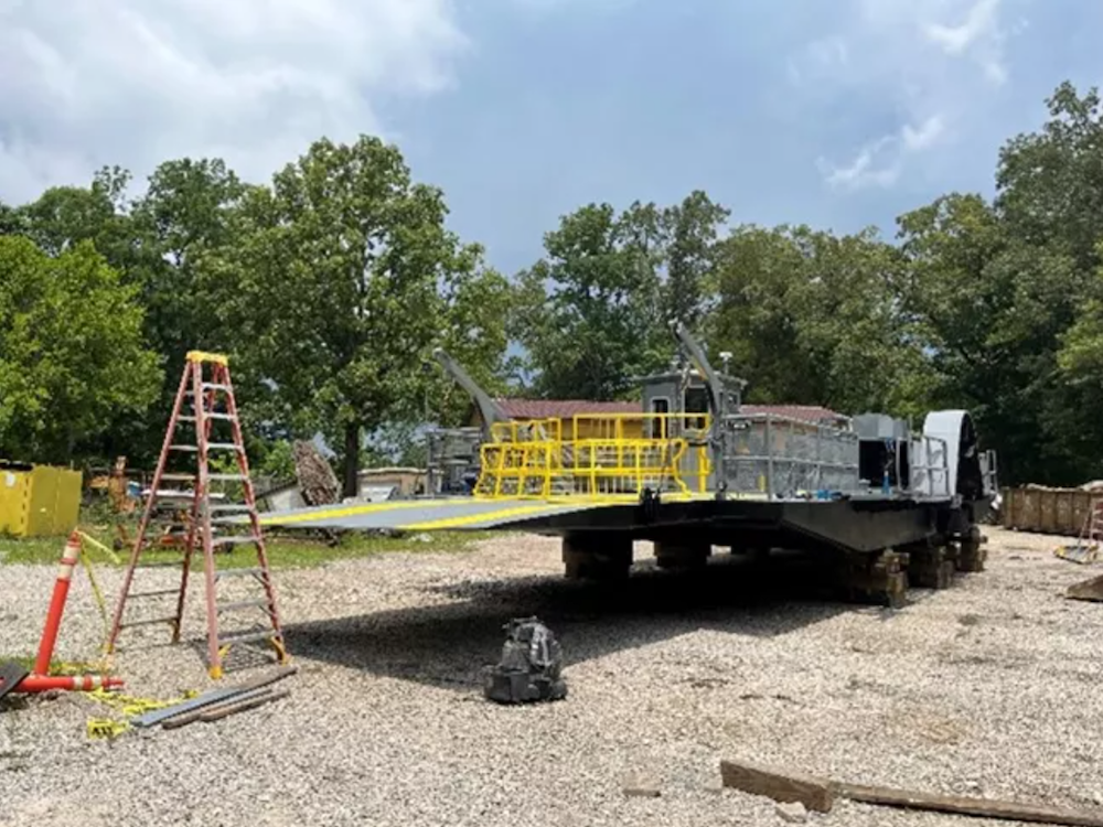
In addition to all the necessary repairs needed to keep the boat floating, the NPS also replaced outdated equipment with new stuff, both to reduce costs and to ensure the boat would pass Coast Guard inspections. As for the upgrades, pontoons were added to the hull to increase capacity from 8 tons to 12 tons.
Not Without Its Faults
I’m glad this ferry exists; it’s cool to know that there’s a river crossing out there that’s broken away from the norm and embraced a fascinating, bygone way of transportation that people can still experience. But it’s not perfect. You probably already know this if you’ve paid a visit to Mammoth Cave National Park in the summer.
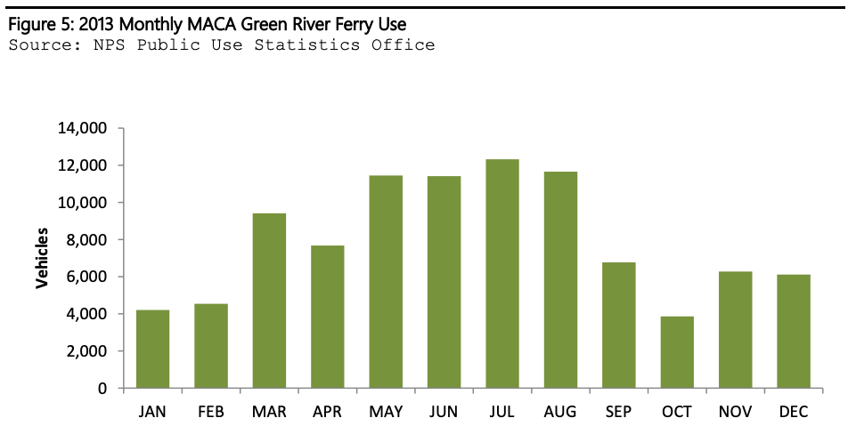
That same study highlights observations on traffic made by park staff, suggesting the ferry’s slow transit times may “degrade the visitor experience.” From the study:
Ferry operators and park staff have stated congestion along Green River Ferry Road can be problematic during peak season (May-August). According to their observations, as many as 30 vehicles may line up along the road waiting to cross the Green River. At low river depths which occur during the peak season, the round trip may take seven minutes or a maximum of seven trips per hour The trip takes longer at higher river depths because the distance between where the water reaches the ramps is longer. With three vehicles per trip, the thirtieth vehicle in line would have to wait more than an hour to cross the river.

There’s also the issue of flooding. Back in April, the Mammoth Cave National Park suffered a historic flooding event that ripped out one of the navigational cable’s support towers and damaged another. The flooding was so bad that it actually moved the 15-ton concrete anchor down the riverbed. From the NPS’s news release:
Traditionally during the month of April, the water level at the Green River Ferry crossing averages between 15 feet to 22 feet with a water flow just under 5,000 cubic feet per second. During the recent flood, the river reached a crest of 59.54 feet with a waterflow of just over 55,000 cubic feet per second. This high volume of water caused a portion of one of the concrete anchors to be physically pulled from the riverbank and moved 20 feet downhill. It also caused extreme stress on the four support towers which are now leaning slightly. Until the cable system and towers are repaired, the ferry cannot operate.
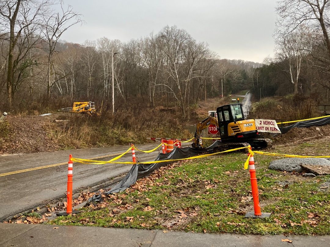
This damage knocked the ferry out of operation for nearly a year, with the service coming back online on March 5. In addition to fixing the cable system, the NPS also replaced the engine and added some flashy new paint. At least now, locals won’t have to do a full 40-mile loop to get to where they need to go. Until another flood comes around and disrupts service again, anyway.
While a properly built bridge would immediately solve these issues, I wouldn’t count on it, seeing as how the NPS just recently spent nearly $4 million upgrading the existing ferry. Maybe in a few decades, when the ferry needs another rejuvenation, the concept of a bridge will be back on the table. But for now, a tiny ferry that travels 200 feet, back and forth for 16 hours a day, is what makes the most sense for Green River.
Top graphic image: National Park Service


Not quite as short a distance, but basically the same ferry, except three of them (all named On Time): https://chappyferry.com/
Came here to say-Green River makes the Chappy Ferry look like a long-haul.
We have something similar in Toronto… a ferry that goes only 400 feet for Billy Bishop Airport in downtown Toronto.
https://www.youtube.com/shorts/nJx8OdSyDu4
This reminds me of my favorite ferry ride. Clinton River Riders ran a bike tour out of St Clair Mi that included taking a small ferry from Algonac across the Detroit River to Walpole Island in Ontario. We’d ride up the Canadian side to a town called Sombra, and ferry back to Marine City to get back to the US side and ride back to the start. The Detroit River was narrow at these points – less than a mile across, so the ferry ride was short. It was fun to say you rode an international ride. The Sombra dock was damaged by an ice floe in 2018, and was too expensive to repair, so that ended that adventure.
I’m really looking forward to riding my bike across the Gordie Howe bridge, that’ll be a nice international ride.
That first youtube video is terrible. “Shortest ferry” video is somehow still not real-time and features several jarring jump cuts. Giving everyone the ability to make badly editing videos was a mistake.
That’s gotta be a fake spider, right? RIGHT?!
In a footnote to the study, the NPS added that ferries are superior to bridges in the rare circumstances when park goers are being pursued by ring wraiths on horseback.
an advantage not many people consider. Glad the NPS is aware
Near us we have the Balboa Island ferry from the Newport Beach peninsula to Balboa Island. It carries three cars plus foot passengers and cyclists. They can run up to three ferries when it’s busy. The government wants them to convert from diesel to electric, which is not feasible. I looked up the distance… under 1000 ft. It is possible to get to the island from land, but the peninsula has a little fun zone and it’s popular to go to the island. You can get a Balboa bar, which is a chocolate dipped ice cream bar with a variety of toppings. I like Heath bar and almond; son likes Oreo, or you can get the works. If you are an Arrested Development fan, the real banana stands are on Balboa Island.
Beat me to it! Good old Admiral, Commodore, and Captain!
From 1906-1940, the Pacific Electric Railway Balboa line ran from Downtown Los Angeles to the Fun Zone at the Balboa Pier.
The harbor is popular for sailors and boaters; you might have to time crossing that part of the (very large) harbor to get to your mooring or slip or to enjoy your day sail.
The harbor is very popular for sea lions, too! When I was growing up my family used to go to Newport and stay for a week or two at the end of August. My sister and I would ride our bikes around all day, go the Fun Zone arcades, get a slice from Pizza Pete’s and take the ferry over to Balboa Island. Now that I am an adult I go there a few times a year and do pretty much the same thing, but also stop and have a beer at Balboa Saloon, Blackie’s, or Malarky’s!
Jess everybody knows the Balboa ferry needs to take you to ‘Yo Adrian’ Island;-)
We still have a few of these around Oregon as well, got to dodge it while doing a canoe trip up the Willamette last summer. Good solution for where a bridge doesn’t make financial sense.
Yeah, they are fun to ride on. For at least one of them (Wheatland), the depth required for footings to reach bedrock and the length of the bridge required to keep it out of the floodplain would require a very expensive bridge.
This immediately struck me as a smaller version of the Wheatland and Canby ferries. I’ve ridden both on bicycle rides but never with a car. There’s another ferry further upstream at Buena Vista and all follow the same format of an electric motor and cables.
The Wheatland was the one I had to canoe past.
https://www.co.marion.or.us/PW/ferries/Pages/buenaferryfees.aspx
Like this one: pronounced “beuna vista”.
A bridge across the Willamette at that location could cost millions. Much more cost effective to keep the ferry in service.
the englishtown and little narrows ferries on cape breton island, NS are both 500′ across, which i’d thought ridiculously short, yet are more than twice as long as this one. aquinah-menemsha bicycle ferry on martha’s vinyard, MA is also 500′ dock-to-dock though the channel is only 160′ across. cant think of any other short ones.
not sure about that paddle wheel, either a normal propellor or wire-rope & winch would be more efficient…surely nostalgia doesn’t play a role in NPS decision making.
The Merrimac Free Ferry crosses the Wisconsin River between Merrimac, Wisconsin and (a bit south) Lodi. It’s a cable ferry that can handle three lanes of traffic and roughly 15 cars. There’s also a lot of pedestrian and bicycle traffic in this very scenic and touristy area. Free is a great price for a short cruise across the river. :^)
The current ferry was built in 2003. There was talk at the time of replacing it with a bridge, but the local area folks rallied for the ferry because it boosts tourism. Their motto? “We do – we do – we do believe in ferries!”
Operation is 24/7 but seasonal, usually April to November. There are ice cream stands at both ends. Check the website before you go…
https://wisconsindot.gov/Pages/travel/water/merrimac/default.aspx
While in the area, check out Devil’s Lake State Park, the old Ringling Bros winter facility at Circus World in Baraboo, and the Mid Continental Railway Museum in North Freedom. There’s also the Midwest Microcar Museum in Mazomanie. Fall colors in the Driftless Region are a thing worth seeing.
As a Wisconsin resident, I’ve ridden the Merrimac Ferry a couple times. Absolutely lovely!
Another Wisconsinite here. I love the ferry (Colsac III), but my wife and many of the residents of Merrimac, WI. would rather have a bridge because they work in Lodi, and in the winter when the ferry is closed their commute triples in time and miles.
Yep. My son lives in Merrimac. If the ferry is closed for the season, it’s a pain to get to town.
Daddy won’t you take me back to Muhlenberg County, down by the Green River, where Paradise lay?
You have excellent taste.
Sorry, Mr. Peabody’s coal train has hauled it away.
Makes sense. If the objective is to also keep the river navigable, this is a whole lot simpler than a draw bridge and with less permitting required. I also imagine the flooding would damage bridges too. The only downsides are the labour and fuel costs.
I used to commute to Rockville, MD, on the White’s Ferry, over the Potomac River, just north of Leesburg, Va. It took about 5 or 6 minutes for the ferry to cross the river, so if you just missed it, it took another 15 minutes to finish the crossing. It was closed when the greedy owners of the land on the Virginia side decided they needed to take a cut of each and every vehicle crossing the river, and no one has been able to change their minds. The last I heard was that Virginia was thinking of using the eminent domain process, which in this case, I totally support.
Wasn’t their argument around some sort of lease violation from expanding the landing without permission or something? I remember a dispute over a lot of new concrete work being part of it somewhere
I’m not sure. I see headlines about it around once a year or so, but I don’t think I’ve heard about that.
Why should the Virginia land owners allow some else to use their land to make money without recompense?
My understanding of it was that it was a quite excessive amount of compensation per car.
I decided to take a look at it on google earth, and then found the tag for Rockland Farm, which owns the land the Va side of the ferry is located on, and boy, the reviews of that estate and the owner were even worse than I knew. So yeah, apparently, the greed was a big part of why nothing has been done.
I was wondering how far I’d have to scroll to see a mention of White’s Ferry. (Pour one out.) I took a road trip vacation back in 2018 and decided to swing through “on the way home”. Not exactly a shortcut, as I was returning to Annapolis from a drive on the Blue Ridge Parkway and Skyline Drive. Still, I’m glad I decided to take the detour. It was a dark night, so you couldn’t see much besides the lights of the ferry and a lot of dark water. It was getting pretty late and I was the only car on that crossing. Quite an experience as the ferry left the landing and I felt the current tug it against the cables.
Honestly, I hope they can come to some accord to get it back in service. Amusing note: Google Maps shows the Virginia Side as “Temporarily Closed”.
Made me think of the Rocky Hill – Glastonbury 4 minute ferry that crosses the Connecticut River. Began in 1655, they say. Used to live very nearby
https://en.wikipedia.org/wiki/Rocky_Hill%E2%80%93Glastonbury_Ferry
Grew up there– my grandfather worked at the ferry and boat ramp for many many years on the RH side. We used to drop our boat in most weekends as a kid, and I spent a good portion of my youth riding my bike through the meadows and over in quarry park too. Good times — haven’t been back in close to 20 years but at first glance, I also thought this was the RH ferry. Great memories.
You can imagine where it goes from here…
Nice – they did fix the cable.
Don’t be fatuous, A. Barth!
I have to believe this requirement is for fitting two vehicles on at a time. 16 feet is actually really short; even a midsize sedan would exceed it, to say nothing of trucks and SUVs.
Yes. I was actually measuring the lengths of my kids’ cars recently. A Honda Fit is just under 14 feet long and a Crosstrek is just under 15.
We did this years ago when my husband drove a crew cab, long box F350 and I drove a Kia Soul. I think they were like 22′ and 13′.
There’s still one ferry operating towards the end of the Columbia River. There’s the Lewis and Clark Bridge that connects Longview, WA with Rainer, OR. Then, 48 miles and about an hour down Highway 30, there’s the famous Megler Bridge in Astoria (As seen in Goonies, Kindergarten Cop, Short Circuit, etc.) that connects to the south side of the Long Beach Washington peninsula.
If you need to cross at any point in between those two spots, there’s the Wahkiakum County Ferry, that leaves every hour at the 15 after mark. $6 a car. And, they’ll take you in-between Westport, OR (A small town that is mostly home to the workers of the nearby paper mill) and the small town of Cathlamet, WA.
I taken that ferry in the past as part of a leisurely motorcycle ride. No real reason to do it beside just to ride the ferry.
In my case my now wife and I had to take that ferry due to a pretty bad accident between Astoria and Westport that blocked traffic both directions on Hwy 30 when we were heading to Ilwaco ~20 years ago.
I haven’t taken it since.
Somewhere in Mammoth Cave is a 2-year-old’s sneaker that fell off my little brother’s foot white he was in my Dad’s backpack carrier.
Seems like it would be a near perfect candidate for electrification.
A 80 HP electric motor is pretty small. Just add an overhead tram style electrical line and a small amount of batteries for running in case of a power outage.
The site is likely not powered, which means that while this would be a good case for electrical power (probably not overhead; just have lines and hawsers on each side of the bank to pull the boat across), actually getting the power lines over would be non-trivial. And the 50-60kw you need to get to 80hp is going to require either a transformer station or really big, buried really deep, cables; that’s (with 220v) a 250 amp pull; with 440, it’s still a more-than-100 amp pull.
There’s a couple of small river ferries in the California delta where I grew up, that run 24 hours a day and carry, at most, a couple of dozen cars per day. They’re free and a fun change of pace, though they’re often down for weeks at a time due to maintenance.
This is Kentucky. I’m assuming they didn’t widely publicize the cheapest option for replacing the ferry – a set of ramps on each bank and a loud YEE-HAW!
I hope one day they add such a ramp a few hundred feet down the river, for those who don’t want to wait in line. It’s a free country, right?
Dibs on the land to build an auto suspension shop on the other side.
Get enough speed and just skip across! Speed Zone sytle!
There’s a slightly longer but still rather short one on the Northern Neck of VA called the Sunnybank ferry. It traverses the Little Wicomico River. Oddly enough the areas it connects are very sparse but people still use it. You can more or less drive around the river from one end to the other in about 15-20 minutes depending on how liberal you want to be with your right foot, but I guess the ferry can save you a few minutes if you’re specifically trying to go from Ophelia to Sunnybank.
I’ve personally never really understood its purpose and have never used it, and we haul our watercraft to a marina on the other side of the river to put it in and take it out of the water every season. Unless you time it perfectly the amount of trouble it saves is kind of negligible, but I’m still happy it exists because it’s neat and charming.
There’s absolutely no economic case for putting a bridge there, and even if they tried I assume it would get nimby’d out of existence because the properties around there are primarily vacation homes, so folks have the resources to be assholes. But every now and then I watch it cross when I’m out on the water being a general annoyance and it gives me a wee pang of joy because I love transit in all forms and it’s just so pleasantly unnecessary. I swear people use it just for fun, which I respect!
Anyway here’s a neat blog post about it. I’d be happy to write one up for the Autopian the next time I’m down there for a few days.
https://www.woodyboater.com/classic-boat-destinations/the-sunnybank-ferry-a-preserved-way-of-life-that-should-never-stop/
We’ve got an ultra short one near me, too, 480 ft river crossing, takes 2 1/2 minutes, supposedly a bridge would cost $80 million as of the last estimate like a decade ago, so obviously much more now, and its not going to happen. Only carries about 225 vehicles a day, but saves about 30 minutes vs alternate routes
I live for this stuff! The area I’m talking about is also home to one of the scariest and most dangerous bridges in Virginia. They’re finally getting around to replacing it soon.
https://en.wikipedia.org/wiki/Robert_O._Norris_Bridge
as soon as i saw the picture i knew what this was! one of our last big family road trips was from tennessee, to kentucky, alabama, and back through georgia in an 87 monte carlo. i was 13 and we stopped at mammoth cave in kentucky for a few days and took several tours including a boat tour up the river to see the original opening. we rode the ferry across and back just to experience it and say we did it. we stopped in huntsville alabama at nasa on the way back through georgia, what an awesome trip. thanks for the memories!
I assume that funding could be cut at any time.
The Bleriot Ferry in Alberta is similarly short. Ferry with ramps is 130 feet long, and the river (depending on water level) is only 280 feet across. It’s much wider and can handle full semis and farm equipment, and is cable driven.
FIrst called the Munson Ferry after the closest town ( Wifes grandfather moved there from Edmonton as it was going to BOOM I think the population is 20 or so) later named after Andre Bleriot the operator, who had a brother Louis who was the first to fly across the English channel- now you understand why I can’t go to heritage sites in Alberta